Wounded Eagle UAS Uses Drone To Map VA West Los Angeles Medical Center Campus | Aero-News Network
Aero-News Network
RSS icon RSS feed
podcast icon MP3 podcast
Subscribe Aero-News e-mail Newsletter Subscribe

Airborne Unlimited -- Most Recent Daily Episodes

Episode Date

Airborne-Monday

Airborne-Tuesday

Airborne-Wednesday Airborne-Thursday

Airborne-Friday

Airborne On YouTube

Airborne-Unlimited-05.06.24

Airborne-NextGen-04.30.24

Airborne-Unlimited-05.01.24 Airborne-AffordableFlyers--05.02.24

Airborne-Unlimited-05.03.24

Tue, Jun 25, 2019

Wounded Eagle UAS Uses Drone To Map VA West Los Angeles Medical Center Campus

Also Created 3D Renderings Of Several Historical Buildings Including The Wadsworth Chapel And Brentwood Theater

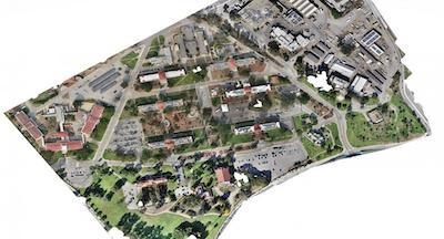
Wounded Eagle (WE) UAS Inc., a veteran run non-profit organization that trains disabled veterans to become experienced and skilled FAA Part 107 UAS operators, has announced that with help from its student UAS operators, it completed aerial mapping of VA Greater Los Angeles Healthcare System's (VAGLAHS) 388-acre VA West Los Angeles Medical Center (WLA) campus.

WE used a UAS and UAS mapping software to capture thousands of images of WLA. The images were stitched together to make a three zone orthomosaic map. WE also created 3D renderings of several historical buildings including the Wadsworth Chapel and Brentwood Theater.

“A truly great opportunity was given to Wounded Eagle UAS by the VA,” says Joseph Dorando, the team lead and remote pilot in charge of UAS operations.

“Our student teams are all disabled veterans and to provide them the capability to learn how to make maps using UAS was a real experience for them and gave them the confidence to do more and go beyond.”

Together, WE and the VAGLAHS Emergency Management Office documented existing facilities and created high-resolution imagery of the entire campus for historical purposes.

The image collections were divided into three zones with the option to merge all three collections together to make one large orthomosaic photogrammetric map of the campus. The resolution is .5 cm per pixel, which allows users to zoom in and view fine details of the buildings such as individual rooftop tiles.

(Image provided with Wounded Eagle news release)

FMI: www.weuas.org

Advertisement

More News

ANN's Daily Aero-Term (05.09.24): Hold Procedure

Hold Procedure A predetermined maneuver which keeps aircraft within a specified airspace while awaiting further clearance from air traffic control. Also used during ground operatio>[...]

ANN's Daily Aero-Term (05.06.24): Altitude Readout

Altitude Readout An aircraft’s altitude, transmitted via the Mode C transponder feature, that is visually displayed in 100-foot increments on a radar scope having readout cap>[...]

ANN's Daily Aero-Linx (05.06.24)

Aero Linx: European Hang Gliding and Paragliding Union (EHPU) The general aim of the EHPU is to promote and protect hang gliding and paragliding in Europe. In order to achieve this>[...]

Airborne-NextGen 05.07.24: AI-Piloted F-16, AgEagle, 1st 2 WorldView Sats

Also: Skydio Chief, Uncle Sam Sues, Dash 7 magniX, OR UAS Accelerator US Secretary of the Air Force Frank Kendall was given a turn around the patch in the 'X-62A Variable In-flight>[...]

Aero-News: Quote of the Day (05.07.24)

"The need for innovation at speed and scale is greater than ever. The X-62A VISTA is a crucial platform in our efforts to develop, test and integrate AI, as well as to establish AI>[...]

blog comments powered by Disqus


Advertisement

Advertisement

Podcasts

Advertisement

© 2007 - 2024 Web Development & Design by Pauli Systems, LC