Wed, May 14, 2014
EASA Certifies The Dual Touchscreen Nav Devices
EASA has certified the installation of the dual touchscreen-controlled Garmin GTN 725 in the ATR 42 and ATR 72 aircraft, Garmin announced Monday, saying the GTN 725 GPS navigators expand the operating utility of the ATR 42/72, by offering Precision-Area Navigation (P-RNAV) capabilities to operators in Europe.
“Garmin continues a legacy of making investments to ensure that operators in Europe have solutions available that offer aircraft the capability to fly shorter routes with higher levels of accuracy,” said Carl Wolf, vice president of aviation sales and marketing. “The GTN 725 is a solution for operators in the ATR 42 and ATR 72 that enables them to fly P-RNAV procedures, which expands the operational capability of the aircraft throughout European airspace.”
When incorporating dual GTN 725s into the ATR 42/72, operators gain additional access to airports with higher levels of operating requirements. The dual GTN 725 installation offers pilots flying the ATR 42/72 the ability to fly shorter, more direct routes in airspaces utilizing P-RNAV procedures. Fewer radar vectors are needed thereby reducing the workload for both the pilot and air traffic control, which streamlines navigation through complex airspace. Similar to the functionality of B-RNAV, P-RNAV procedures feature the same capability with a higher level of accuracy.
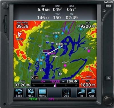
Complete with a range of advanced flight display capabilities, the GTN 725 offers operators rich, interactive mapping that also displays airspace, frequency information and more. The touchscreen interface allows pilots to graphically edit flight plans on the moving map display, providing an easy and intuitive way to make flight plan modifications at any time.
The GTN 725 is compatible with optional Garmin ChartView powered by Jeppesen. Instrument Approach Procedures are conveniently overlaid on the moving map display, offering operators elevated situational awareness when transitioning from the enroute to approach phases of flight. Garmin SafeTaxi airport diagrams are conveniently geo-referenced on the GTN 725 so runways, taxiways, FBO’s and hangars are easily identifiable and navigating around unfamiliar airports is simplified.
(Image provided by Garmin)
More News
From 2023 (YouTube Version): Legacy of a Titan Robert (Bob) Anderson Hoover was a fighter pilot, test pilot, flight instructor, and air show superstar. More so, Bob Hoover was an i>[...]
Get The Latest in Aviation News NOW on Instagram Are you on Instagram yet? It's been around for a few years, quietly picking up traction mostly thanks to everybody's new obsession >[...]
Aero Linx: B-52H Stratofortress The B-52H Stratofortress is a long-range, heavy bomber that can perform a variety of missions. The bomber is capable of flying at high subsonic spee>[...]
Altimeter Setting The barometric pressure reading used to adjust a pressure altimeter for variations in existing atmospheric pressure or to the standard altimeter setting (29.92).>[...]
"Knowing that we play an active part in bettering people's lives is extremely rewarding. My team and I are very thankful for the opportunity to be here and to help in any way we ca>[...]
 Classic Aero-TV: Remembering Bob Hoover

