Tue, Mar 08, 2011
STC Will Cover All R44 Models
Garmin announced Sunday that it has initiated work on a project
to obtain an STC for installation of the Garmin G500H glass cockpit
in the Robinson R44 helicopter. Once completed, any authorized
Garmin dealer can install the G500H in an R44 in accordance with
FAA guidelines. The STC will cover all models of the R44
helicopter.
R44s presently equipped with a 10-hole instrument panel will be
able to install the G500H display directly into the instrument
panel. R44s equipped with seven or nine hole instrument panels will
be able to install Garmin’s PMA’d parts kit that will
replace the instrument panel assembly with a new Garmin designed
assembly optimized for G500H.
This new instrument panel assembly puts the G500H display within
easy reach and view of the pilot yet is small enough that the view
outside the cockpit is excellent. “The G500H is becoming a
very popular avionics suite with the helicopter community because
of its vast capability and flexibility,” said Gary Kelley,
Garmin’s vice president of marketing. “With nearly
5,000 R44 helicopters in service around the world, Garmin is
pleased to offer the benefits of the G500H to this large community
of helicopter operators.”

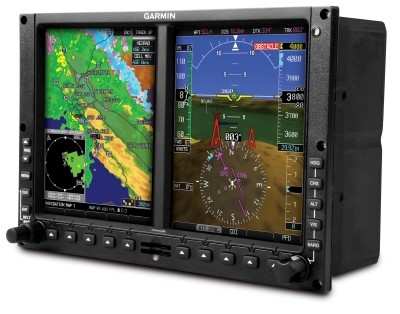
The G500H is an all-glass avionics system designed specifically
for the VFR Part 27 helicopter market. The primary flight display
(PFD) shows attitude, airspeed, vertical speed, altitude and
course/heading information, and the multi-function display (MFD)
has detailed moving map graphics with the helicopter’s
current position in relation to terrain, chart data, navaids,
and flight plan routings. The system offers features like
helicopter synthetic vision technology (HSVT), XM WX Satellite
Weather with NEXRAD, the ability to display video from a forward
looking infrared (FLIR) camera or other video sources, and a
helicopter-specific database with over 7,000 heliports and nearly
30,000 additional low altitude obstacles in addition to the already
extensive obstacle database found in the fixed-wing G500
system.
Garmin anticipates receiving the STC for the Robinson R44 in the
fourth quarter of 2011.
More News
DETRESFA (Distress Phrase) The code word used to designate an emergency phase wherein there is reasonable certainty that an aircraft and its occupants are threatened by grave and i>[...]
"General aviation is at the forefront of developing and introducing innovative technologies that will transform the entire aviation industry..." Source: Kyle Martin, Vice President>[...]
Direct Straight line flight between two navigational aids, fixes, points, or any combination thereof. When used by pilots in describing off-airway routes, points defining direct ro>[...]
Aero Linx: Women in Corporate Aviation Women in Corporate Aviation support individuals seeking career advancement and professional development in the business aviation industry. Me>[...]
“We would like to thank the many volunteers that help throughout the year to pull off the event, as well as the several reviewers, judges, and SURVICE staff that provide team>[...]
 ANN's Daily Aero-Term (04.26.24): DETRESFA (Distress Phrase)

