Sat, Oct 27, 2007
 NOTAM Number: FDC 7/1913
Issue Date: October 26, 2007 at 0037 UTC
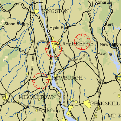
Location: New Windsor, New York
Beginning Date and Time: October 29, 2007 at 0250 UTC
Ending Date and Time: October 29, 2007 at 2150 UTC
Reason for NOTAM: Temporary flight restrictions for VIP (Very
Important Person) Movement
Type: VIP
Replaced NOTAM(s): N/A
Affected Area(s)
Area A
Airspace Definition:
Center: 16 nautical miles from KINGSTON VOR/DME(IGN) on the
244 radial (Latitude: 41º30'03"N, Longitude:
74º06'03"W)
Radius: 3 nautical miles
Altitude: From the surface up to but not including 3000 feet
AGL
Effective Date(s):
From October 29, 2007 at 0250 UTC (October 28, 2007 at 2250
EDT)
To October 29, 2007 at 0340 UTC (October 28, 2007 at 2340
EDT)
Area B
Airspace Definition:
Center: 4.8 nautical miles from KINGSTON VOR/DME(IGN) on the
288 radial (Latitude: 41º40'26"N, Longitude:
73º55'44"W)
Radius: 3 nautical miles
Altitude: From the surface up to but not including 3000 feet
AGL
Effective Date(s):
From October 29, 2007 at 0330 UTC (October 28, 2007 at 2330
EDT)
To October 29, 2007 at 1150 UTC (October 29, 2007 at 0750
EDT)
Area C
Airspace Definition:
Center: 6.4 nautical miles from KINGSTON VOR/DME(IGN) on the
097 radial (Latitude: 41º40'27"N, Longitude:
73º40'50"W)
Radius: 3 nautical miles
Altitude: From the surface up to but not including 3000 feet
AGL
Effective Date(s):
From October 29, 2007 at 1140 UTC (October 29, 2007 at 0740
EDT)
To October 29, 2007 at 2055 UTC (October 29, 2007 at 1655
EDT)
Area D
Airspace Definition:
Center: 16 nautical miles from KINGSTON VOR/DME(IGN) on the
244 radial (Latitude: 41º30'03"N, Longitude:
74º06'03"W)
Radius: 3 nautical miles
Altitude: From the surface up to but not including 3000 feet
AGL
Effective Date(s):
From October 29, 2007 at 2100 UTC (October 29, 2007 at 1700
EDT)
To October 29, 2007 at 2150 UTC (October 29, 2007 at 1750
EDT)
Operating Restrictions and Requirements
No pilots may operate an aircraft in the areas covered by this
NOTAM (except as described).
Unless otherwise authorized by ATC.
Other Information:
ARTCC: ZBW - Boston Center
Authority: Title 14 CFR section 91.141
FMI: www.tfr.faa.gov,
Depicted TFR data may not be a complete listing. Pilots should not
use the information on this website for flight planning purposes.
For the latest information, call your local Flight Service Station
at 1-800-WX-BRIEF.
More News
Say Altitude Used by ATC to ascertain an aircraft's specific altitude/flight level. When the aircraft is climbing or descending, the pilot should state the indicated altitude round>[...]
Aero Linx: European Air Law Association (EALA) EALA was established in 1988 with the aim to promote the study of European air law and to provide an open forum for those with an int>[...]
From 2023 (YouTube Version): The Life, Death, Life, Death, and Life of a Glorious Warbird In 1981, business-owner Jim Tobul and his father purchased a Chance-Vought F4U Corsair. Mo>[...]
Also: USCG Retires MH-65 Dolphins, Irish Aviation Authority, NATCA Warns FAA, Diamond DA42 AD This summer, history enthusiasts will have a unique opportunity to experience World Wa>[...]
Also: WACO Kitchen Bails, French SportPlane Mfr to FL, Dynon-Advance Flight Systems, Innovation Preview Bobby Bailey, a bit of a fixture in sport aviation circles for his work with>[...]
 ANN's Daily Aero-Term (05.01.24): Say Altitude

