Killer Wave Tracked From Orbit
For the first time, orbiting satellites have observed and
measured a major tsunami event in open ocean, the Indian Ocean
tsunami that resulted from the magnitude 9 earthquake southwest of
Sumatra on December 26. The measurements are of tremendous value to
researchers worldwide and will aid our understanding of these
events.
US and French teams working in parallel with altimetry data from
the joint NASA/French Space Agency Jason and Topex/Poseidon
oceanography satellites have independently confirmed the
satellites' measurements of the height of the tsunami waves as they
radiated from the earthquake's epicenter. The satellites flew over
the Bay of Bengal about 150 kilometers (93 miles) apart
approximately two hours after the quake.
"These two satellites make only about 13 Earth revolutions
daily, with each orbit passing over the Earth approximately 3,000
kilometers (1,864 miles) away from its last," said Dr. Philip
Callahan of NASA's Jet Propulsion Laboratory, Pasadena, Calif.
Callahan has been searching for tsunami signals in satellite radar
altimeter data since Topex/Poseidon's launch in 1992. "There is a
very low probability of capturing observations in any given
location within two hours of an event like this. The fact that
Jason captured the tsunami's signals is serendipitous, but is
nevertheless a major boon for oceanographers," he said.
"The observations made by Jason and Topex/Poseidon are unique
and of tremendous value for testing and improving tsunami computer
models and developing future tsunami early warning systems," said
JPL's Dr. Lee-Lueng Fu, Jason and Topex/Poseidon project scientist.
"The satellite altimeter data currently take a minimum of five
hours to process, so they cannot provide early warning of such
events," said Fu. Dr. Callahan received the Jason data the morning
of December 27.
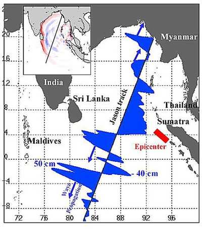
The main figure displays changes in sea surface height from
previous observations made along the same ground track 20 to 30
days before the earthquake, showing the signals of the tsunami
waves. The inset is a computer model of simulated changes in sea
surface height created by Kenji Satake of the National Institute of
Advanced Industrial Science and Technology, Japan. It provides a
basin-wide perspective for interpreting the Jason and
Topex/Poseidon satellite observations, which are in good agreement
with the model.
The satellites recorded a maximum sea surface elevation gain
(deviation from normal) of 50 centimeters (1.6 feet) on the open
ocean about 1,200 kilometers (746 miles) south of Sri Lanka at the
leading crest of a tsunami wave raging out of the Bay of Bengal. It
was followed by a trough of sea surface depression of 40
centimeters (1.3 feet) below normal. The distance from one wave
crest to the next was about 800 kilometers (500 miles). The first
wave was followed by a second with a crest height of 40 centimeters
(1.3 feet) above normal. Near the northern end of the Bay, two
waves with crest heights of 40 centimeters (1.3 feet) and 20
centimeters (0.66 feet) above normal were approaching the coasts of
Myanmar. Spreading across the Bay of Bengal from the earthquake
zone offshore from Western Sumatra, these tsunami waves eventually
reached shallow waters along the coasts of Sumatra, Sri Lanka,
Thailand and Southern India. Their open ocean speeds reduced from
that of a jet plane, 800 kilometers (500 miles) per hour, to about
32 kilometers (20 miles) per hour, building the open ocean wave
heights of 0.5 meters (1.6 feet) or less to walls of water up to 10
meters (33 feet) high with great destructive power.
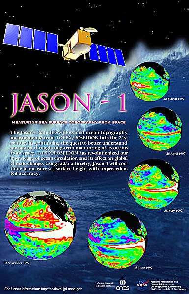
Jason and Topex/Poseidon are collaborative satellite missions of
NASA and the French Space Agency, Centre National d'Estudes
Spatiales. The primary objectives of the two missions are to make
long-term measurements of the height of the world's sea surface to
better understand ocean circulation and its effects on climate.
"The information on sea surface height from these satellites has
many other applications, and can be used to aid navigation,
offshore operations, hurricane forecasting, fisheries, etcetera,"
said Dr. Yves Menard, Jason and Topex/Poseidon project scientist at
the Centre National d'Estudes Spatiales. "The detection of these
tsunami waves provides yet another demonstration of the important
value of satellite radar altimeter observations."
NASA and the French Space Agency are working with the National
Oceanic and Atmospheric Administration and the European
Organization for the Exploitation of Meteorological Satellites to
develop the next radar altimeter mission, the Ocean Surface
Topography Mission, targeted for launch in 2008. It will make radar
altimeter measurement a routine operation of those organizations in
the future.
 ANN's Daily Aero-Term (04.25.24): Airport Rotating Beacon

