Mon, Jun 10, 2013
IRIS Will Observe How Solar Material Reacts In Sun's Atmosphere
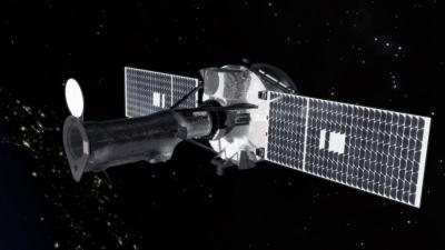
NASA's next scientific satellite, which is scheduled for launch June 26, will provide the most detailed look ever at the sun's lower atmosphere or interface region. The Interface Region Imaging Spectrograph (IRIS) mission will observe how solar material moves, gathers energy, and heats up as it travels through this largely unexplored region of the solar atmosphere. The interface region, located between the sun's visible surface and upper atmosphere, is where most of the sun's ultraviolet emission is generated. These emissions impact the near-Earth space environment and Earth's climate.
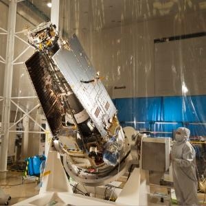
The IRIS spacecraft was designed and built by Lockheed Martin's Advanced Technology Center in Palo Alto, CA. It will launch aboard a Pegasus XL rocket deployed by an Orbital Sciences L-1011 aircraft from Vandenberg Air Force Base on the central California coast. "IRIS data will fill a crucial gap in our understanding of the solar interface region upon joining our fleet of heliophysics spacecraft," said Jeffrey Newmark, NASA's IRIS program scientist in Washington. "For the first time we will have the necessary observations for understanding how energy is delivered to the million-degree outer solar corona and how the base of the solar wind is driven."
IRIS carries an ultraviolet telescope that feeds a multi-channel imaging spectrograph. The satellite is the first mission designed to use an ultraviolet telescope to obtain high-resolution images and spectra every few seconds and provide observations of areas as small as 150 miles across the sun. "Previous observations suggest there are structures in this region of the solar atmosphere 100 to 150 miles wide, but 100,000 miles long," said Alan Title, IRIS principal investigator at Lockheed Martin. "Imagine giant jets like huge fountains that have a footprint the size of Los Angeles and are long enough and fast enough to circle Earth in 20 seconds. IRIS will provide our first high-resolution views of these structures along with information about their velocity, temperature and density."
After launch, IRIS will travel in a polar, sun-synchronous orbit around Earth, crossing nearly directly over the poles in such a way that it moves over the equator at the same local time each day. The spacecraft will orbit at an altitude range of 390 miles to 420 miles. This orbit allows for almost continuous solar observations on IRIS' two-year mission.
(Images provided by NASA)
More News
How To Get A Story On Aero-TV News/Feature Programming How do I submit a story idea or lead to Aero-TV? If you would like to submit a story idea or lead, please contact Jim Campbel>[...]
Aero Linx: International Association of Professional Gyroplane Training (IAPGT) We are an Association of people who fly, build or regulate Gyroplanes, who have a dream of a single >[...]
NORDO (No Radio) Aircraft that cannot or do not communicate by radio when radio communication is required are referred to as “NORDO.”>[...]
Also: uAvionix AV-Link, F-16 Viper Demo, TN National Guard, 'Staff the Towers' A Saturday afternoon jump run, originating from SkyDive Kansas City, went bad when it was reported th>[...]
Beyond Visual Line Of Sight (BVLOS) The operation of a UAS beyond the visual capability of the flight crew members (i.e., remote pilot in command [RPIC], the person manipulating th>[...]
 ANN FAQ: Contributing To Aero-TV