Thu, Jan 14, 2016
Most Of The Western Hemisphere To Benefit From Better Severe Weather Warning
The second Geostationary Lightning Mapper (GLM) instrument that will provide earlier alerts of severe storms and contribute to more accurate tornado warnings has been delivered by Lockheed Martin. The sensor will fly on the second next-generation Geostationary Operational Environmental Satellite, known as GOES-S, for the National Oceanic and Atmospheric Administration (NOAA).
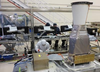
The Lockheed Martin team successfully completed assembly, integration, test and delivery of the second GLM instrument only 13 months after the first delivery.
"We reduced the build and test time of this complex instrument by 40 percent compared to the first unit," said Jeff Vanden Beukel, Lockheed Martin GLM program director. "Now that development is complete, we are able to reduce delivery time so the GOES program can serve our nation with more accurate weather information."
A rapid increase of in-cloud lightning can precede severe weather on the ground. GLM tracks that activity and gives faster warning plus more precise location information versus current systems. It does this by tracking lightning flashes from geostationary orbit, with continuous coverage of the United States and most of the Western Hemisphere. The heart of the GLM instrument is a high-speed (500 frames per second), 1.8 megapixel focal plane, integrated with low-noise electronics and specialized optics to detect weak lightning signals, even against bright, sunlit cloud backgrounds. It was developed at Lockheed Martin's Advanced Technology Center in Palo Alto.
GOES satellites are a key element in NOAA's National Weather Service operations, providing a continuous stream of weather imagery and sounding data used to support weather forecasting, severe-storm tracking and meteorological research. The GOES program is managed and operated by NOAA, and NASA's Goddard Space Flight Center manages GLM instrument development. The team is preparing GLM for integration on the GOES-S spacecraft at Lockheed Martin's facility near Denver.
(Image provided with Lockheed Martin news release)
More News
Known Traffic With respect to ATC clearances, means aircraft whose altitude, position, and intentions are known to ATC.>[...]
Aero Linx: Aviation Suppliers Association (ASA) Established February 25, 1993, the Aviation Suppliers Association (ASA), based in Washington, D.C., is a not-for-profit association,>[...]
Abeam An aircraft is “abeam” a fix, point, or object when that fix, point, or object is approximately 90 degrees to the right or left of the aircraft track. Abeam indic>[...]
Aero Linx: The Air Charter Safety Alliance The group, called the Air Charter Safety Alliance, will raise awareness of illegal charter flights among potential customers, charter bro>[...]
“For months, ALPA has been sounding the alarm on the ongoing efforts by some aircraft manufacturers to remove pilots from the flight deck and replace them with automation. To>[...]
 ANN's Daily Aero-Term (06.10.24): Known Traffic