Impact Into Mountainous Terrain Takes Four Lives
A charter flight went down late last month after the pilot of
the Beech Baron reported a fire shortly before the aircraft
impacted in mountainous territory. The controller inquired as to
the pilot's intentions... but no response was made as the radar
returns indicated a fast descent before the aircraft disappeared
and subsequently was reported down. Conditions were clear and
eyewitness reports indicate the aircraft made a sharp turn before
impact. Witnesses also made reports that seemed to indicate the
possibility of some kind of power issues...

NTSB Identification: ERA11FA312
Nonscheduled 14 CFR Part 135: Air Taxi & Commuter
Accident occurred Wednesday, May 25, 2011 in Murphy, NC
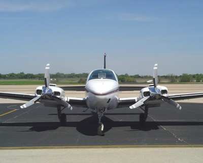
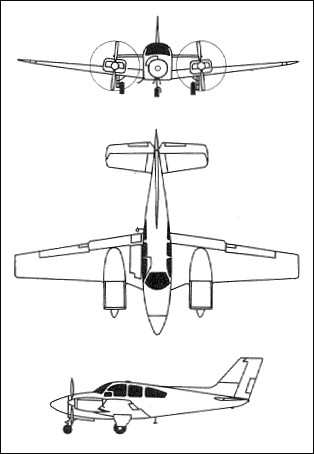
Aircraft: BEECH 58, registration: N77AR
Injuries: 4 Fatal.
This is preliminary information, subject to change, and may
contain errors. Any errors in this report will be corrected when
the final report has been completed.
On May 25, 2011, about 1615 eastern daylight time, a Beech 58,
N77AR, collided with mountainous terrain near Murphy, North
Carolina. The certificated airline transport pilot and three
passengers were fatally injured and the airplane was destroyed. The
airplane was registered to Aero Resources Corporation, operated by
Friendship Flying Service, Inc., under the provisions of 14 Code of
Federal Regulations (CFR) Part 135 as an on-demand, non-scheduled,
domestic passenger flight to Wendell H Ford Airport (K20), Hazard,
Kentucky. Visual meteorological conditions prevailed in the area at
the time of the accident and an instrument flight rules (IFR)
flight plan was filed. The flight originated from Fulton County
Airport (FTY), Atlanta, Georgia, about 1545.
According to preliminary information, the flight plan indicated
3 on board; however, the airplane operator reported that an
additional individual asked the pilot before departure to be flown
to K20.
Preliminary air traffic control (ATC) information indicates that
after takeoff, the flight proceeded towards the destination airport
and while flying at 9,000 feet mean sea level (msl), in
communication with the Atlanta Air Route Traffic Control Center
(Atlanta ARTCC), ATC communications were transferred to Knoxville
Terminal Radar Approach Control (Knoxville TRACON. The pilot
established contact with that facility but the radar controller did
not answer immediately due to workload. Less than 30 seconds later
the controller responded to the pilot and at about 1612. The pilot
advised the controller that there was a fire and he was declaring
an emergency; the pilot did not specify where the fire was located.
The radar controller asked the pilot if he was going to land; the
pilot did not respond and there were no further recorded
transmissions received from the pilot. Radar data indicates three
successive radar returns at 8,900, 8,700, and 8,500 feet msl. No
further radar returns were received from the flight.
A witness reported to a Federal Aviation Administration
inspector he heard a twin-engine airplane flying overhead his
location, and observed the airplane flying straight and level about
1,500 feet above the mountains in a northwesterly direction. The
witness reported hearing the engines accelerate and the airplane
continued briefly then the right wing dipped and the airplane
pitched nose down. While in the nose-low attitude the witness heard
the engines accelerate more. He lost sight of the airplane over the
ridge and heard an explosion seconds later. He could not see the
registration markings or individuals inside, but reported he did
not notice any smoke or flames coming from the airplane before
losing sight behind the ridge.
Another witness who was located at the Unaka Community Cemetery,
and who was outside, reported first hearing the airplane. He
reported the sound was loud which was what caught his attention and
was consistent with a low flying airplane. He pointed out that the
airplane was flying towards his position at the cemetery from the
approximate location of the Hiwassee Dam Lake (approximately 060
degrees). He did not notice any extreme nose low or nose high pitch
position. He noted that the airplane made a “sharp right
turn” confirming the direction of the turn. The airplane then
went behind trees and he heard an explosion much like a
“sonic boom.” He then saw a puff of black smoke.
Immediately after the explosion he looked at his watch with
reflected 1618 hours local. Another individual came to the
cemetery, and they both went towards the area where they thought
the airplane had crashed. They went down Joe Brown Highway, then
turned onto Allen Bell Road. They drove to a house close to the
crash site and hiked down to a creek. They went into the creek and
about 50 to 60 yards downstream, saw smoke to their left. They saw
a wing on the right side of the creek as they were walking. When
they were about 25 yards from the crash site, he reported there was
an explosion. The smoke was intense, and about that time, 1 acre of
woods were on fire. He looked at his watch and noted the tine he
arrived on-scene was about 1640. He reported the weather conditions
were clear and sunny.
Still another witness who was located at his house near the
crash site reported hearing a low flying airplane with engine
surging. He then heard a loud explosion which rattled his windows.
He initially thought lightning had struck the house. He went onto
his deck, and saw smoke. He and several individuals went to the
crash site area and were on-scene about 10 minutes after the crash.
When they arrived he noted that the fuselage was on fire, which was
not spreading fast. He did not notice anything on fire on his side
of the creek. He heard an explosion on the side he was on. A
noticed a lot of paperwork with no char marks. The witness reported
that there was no rain or breeze at the time, and the clouds were
scattered. About 30 minutes after the crash he noted a helicopter
was overhead. He estimated the time of the accident about 1615.
The cockpit and cabin area of the fuselage was nearly consumed
by fire; structural components of the airplane consisting of a
section of the right wing, outer portion of the left wing, and left
horizontal stabilizer were located outside of the postcrash fire
area.
FMI: www.ntsb.gov
 Airborne 05.20.24: Van's BK Exit, Bud Anderson, Air Race Classic

