NTSB Releases Preliminary Report On South Dakota Accident Investigation | Aero-News Network
Aero-News Network
RSS icon RSS feed
podcast icon MP3 podcast
Subscribe Aero-News e-mail Newsletter Subscribe

Airborne Unlimited -- Most Recent Daily Episodes

Episode Date

Airborne-Monday

Airborne-Tuesday

Airborne-Wednesday Airborne-Thursday

Airborne-Friday

Airborne On YouTube

Airborne-Unlimited-05.20.24

Airborne-Unlimited-05.28.24

Airborne-FlightTraining-05.29.24 Airborne-Unlimited-05.30.24

Airborne-Unlimited-05.24.24

Thu, Dec 19, 2019

NTSB Releases Preliminary Report On South Dakota Accident Investigation

Nine Fatally Injured When A Pilatus PC12 Went Down

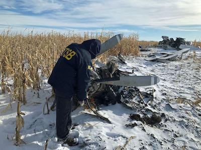
The National Transportation Safety Board issued its preliminary report Tuesday for its investigation of the Nov. 30, 2019, crash of a Pilatus PC12 in Chamberlain, South Dakota, which killed the pilot and eight passengers and injured three others.

The airplane was registered to Conrad & Bischoff, Inc., and operated by the pilot as a personal flight from Chamberlain Municipal Airport destined for Idaho Falls Regional Airport, Idaho.

According to preliminary data recovered from the data recorder installed on the airplane, the accident takeoff began from runway 31 about 12:31 p.m. central standard time. The airplane immediately rolled about 10 degrees to the left after takeoff. The roll decreased to about five degrees left as the airplane climbed through about 170 feet above ground level and then reversed to about five degrees right. The airplane ultimately entered a 64-degree left bank as the airplane reached its peak altitude of 460 feet above the ground. The cockpit stall warning and stick shaker became active about one second after liftoff and the stick pusher became active about 15 seconds after liftoff. They continued intermittently for the duration of the flight. The data recording ended about 12:33 p.m.

No radio communications were received from the pilot, and radar contact was never established.

The recorder also captured cockpit sound. The NTSB will convene a group of technical experts to produce a transcript.

Weather at the time was recorded as being overcast with clouds at 500 feet, 1/2-mile visibility in moderate snow, with wind from the direction of 20 degrees at 6 knots. The temperature and dew point were both 1 degree Celsius, and the altimeter setting was 29.30 inches of mercury. Freezing rain and snow were observed in the vicinity of the airport the previous afternoon and overnight before the accident flight, which was operated on an instrument flight rules flight plan.

Witnesses reported that the pilot and a passenger worked for three hours to remove the snow and ice from the airplane before the accident flight. The witnesses reported that visibility was limited by snow at the time of the accident.

The accident site was located at 1:57 p.m. approximately three-fourths of a mile west of the airport in a dormant corn field. The debris path was approximately 85 feet long and was oriented on a 179-degree heading.

(Source: NTSB news release. Image from file)

FMI: go.usa.gov/xpfsq

Advertisement

More News

ANN FAQ: Contributing To Aero-TV

How To Get A Story On Aero-TV News/Feature Programming How do I submit a story idea or lead to Aero-TV? If you would like to submit a story idea or lead, please contact Jim Campbel>[...]

ANN's Daily Aero-Linx (05.29.24)

Aero Linx: International Association of Professional Gyroplane Training (IAPGT) We are an Association of people who fly, build or regulate Gyroplanes, who have a dream of a single >[...]

ANN's Daily Aero-Term (05.29.24): NORDO (No Radio)

NORDO (No Radio) Aircraft that cannot or do not communicate by radio when radio communication is required are referred to as “NORDO.”>[...]

Airborne 05.28.24: Jump Plane Down, Starship's 4th, Vision Jet Problems

Also: uAvionix AV-Link, F-16 Viper Demo, TN National Guard, 'Staff the Towers' A Saturday afternoon jump run, originating from SkyDive Kansas City, went bad when it was reported th>[...]

ANN's Daily Aero-Term (05.30.24): Beyond Visual Line Of Sight (BVLOS)

Beyond Visual Line Of Sight (BVLOS) The operation of a UAS beyond the visual capability of the flight crew members (i.e., remote pilot in command [RPIC], the person manipulating th>[...]

blog comments powered by Disqus


Advertisement

Advertisement

Podcasts

Advertisement

© 2007 - 2024 Web Development & Design by Pauli Systems, LC