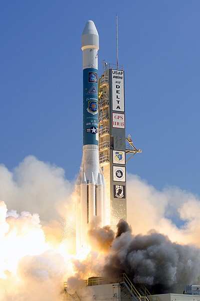
Delta II Blasts Another GPS Satellite To Orbit | Aero-News Network
Aero-News Network
RSS icon RSS feed
podcast icon MP3 podcast
Subscribe Aero-News e-mail Newsletter Subscribe

Airborne Unlimited -- Most Recent Daily Episodes

Episode Date

Airborne-Monday

Airborne-Tuesday

Airborne-Wednesday Airborne-Thursday

Airborne-Friday

Airborne On YouTube

Airborne-Unlimited-04.29.24

Airborne-NextGen-04.30.24

Airborne-Unlimited-05.01.24 Airborne-AffordableFlyers--05.02.24

Airborne-Unlimited-05.03.24

Tue, Sep 26, 2006

Delta II Blasts Another GPS Satellite To Orbit

Chalk One Up For Boeing IDS

Boeing's workhorse Delta II launch booster successfully lifted a replenishment Block IIR Global Positioning System (GPS) satellite for the US Air Force on Sunday.

The Delta II rocket carrying the GPS IIR-15 (M) spacecraft lifted off from Space Launch Complex 17A at Cape Canaveral Air Force Station, FL at 2:50 pm EDT September 24. Following a nominal 68-minute flight, the rocket deployed the satellite to a transfer orbit.

"We are honored to have a continuing role in maintaining the GPS constellation, which is so vital to our nation's defense and security," said Dan Collins, vice president, Boeing Launch Systems. "The Delta team has launched all the GPS-II spacecraft and we look forward to continuing with the delivery of the replenishment satellites to keep the constellation operable 24-7."

The Boeing Delta II 7925-9.5 configuration vehicle used for the mission featured a Boeing first stage booster powered by a Pratt & Whitney Rocketdyne RS-27A main engine and nine Alliant Techsystems (ATK) solid rocket boosters. An Aerojet AJ10-118K engine powered the storable propellant restartable second stage. A Thiokol Star-48B solid rocket motor propelled the third stage prior to spacecraft deployment. The rocket also flew with a nine-and-a-half-foot-diameter Boeing payload fairing.

A redundant inertial flight control assembly built by L3 Communications Space & Navigation provided guidance and control for the rocket that enabled a precise deployment of the satellite.

Boeing provides launches for the GPS program aboard Delta II vehicles and has a planned GPS manifest through at least 2007. The GPS IIR-15 (M) is the second of the modernized GPS satellites that incorporates various improvements to provide greater accuracy, increased resistance to interference and enhanced performance for users.

The GPS network supports U.S. military operations conducted from aircraft, ships, land vehicles and by ground personnel. Additional use includes mapping, aerial refueling and rendezvous, geodetic surveys, and search and rescue operations.

GPS provides military and civilian users three-dimensional position location data in longitude, latitude and elevation as well as precise time and velocity. The satellites orbit the Earth every 12 hours, emitting continuous navigation signals. The signals are so accurate, time can be figured to within one millionth of a second, velocity within a fraction of a mile-per-second and location to within 100 feet.

A unit of The Boeing Company, Boeing Integrated Defense Systems is one of the world's largest space and defense businesses. Headquartered in St. Louis, MO, Boeing Integrated Defense Systems is a $30.5 billion business.

FMI: www.boeing.com

Advertisement

More News

ANN's Daily Aero-Term (05.02.24): Touchdown Zone Lighting

Touchdown Zone Lighting Two rows of transverse light bars located symmetrically about the runway centerline normally at 100 foot intervals. The basic system extends 3,000 feet alon>[...]

Aero-News: Quote of the Day (05.02.24)

“Discovery and innovation are central to our mission at Virgin Galactic. We’re excited to build on our successful record of facilitating scientific experiments in subor>[...]

Aero-News: Quote of the Day (05.03.24)

"We are reaching out to you today on behalf of the Popular Rotorcraft Association because we need your help. We are dangerously close to losing a critical resource that if lost, wi>[...]

ANN's Daily Aero-Term (05.03.24): UAS Traffic Management (UTM)

UAS Traffic Management (UTM) The unmanned aircraft traffic management ecosystem that will allow multiple low altitude BVLOS operations and which is separate from, but complementary>[...]

ANN's Daily Aero-Linx (05.03.24)

Aero Linx: Society of Aviation and Flight Educators (SAFE) SAFE is a member-oriented organization of aviation educators fostering professionalism and excellence in aviation through>[...]

blog comments powered by Disqus


Advertisement

Advertisement

Podcasts

Advertisement

© 2007 - 2024 Web Development & Design by Pauli Systems, LC