Offers Intuitive Navigation, Charts, Flight Planning And Filing Capabilities
Garmin Pilot, a new aviation app for iOS devices, including the iPad and iPhone, and Android-based mobile devices, was introduced Tuesday by the company. The app brings Garmin’s aviation features to tablets and smart phones, offering pilots complete navigation, trip planning, DUAT(S) filing, weather and electronic flight bag capabilities.
“From integrated flight decks to mobile apps, Garmin is committed to providing our customers with a broad suite of best-in-class products,” said Carl Wolf, Garmin’s vice president of aviation sales and marketing. “Garmin Pilot is the perfect complement to our extensive line of avionics products and services. And because it incorporates the intuitive pilot interface, easy-to-use menu icons and many of the same great features from our other popular systems, pilots will find it very familiar and easy to use.”
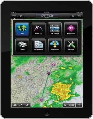
Garmin Pilot’s powerful capabilities start with pre-flight planning, providing the information pilots need to make better-informed flight decisions. With access to the most comprehensive aviation weather information for the U.S. and Canada, pilots can check NEXRAD radar, visible and infrared cloud imagery, METARs, TAFs, AIRMETs, SIGMETs, PIREPs, NOTAMs, winds and temperature aloft, TFRs and lightning data. Pilots can also overlay weather on the map, add text-based weather widgets and use the NavTrack feature to look ahead along the planned route to preview weather conditions. Using their DUAT(S) account, pilots can receive and log FAA-approved weather briefings that meet legal briefing requirements.
Additional pre-flight planning tools available with the app include access to the AOPA Airport Directory, fuel pricing information to help plan refueling stops, as well as built-in calculators to estimate fuel burn, enroute legs and arrival times.
With Garmin Pilot, users can easily enter a flight plan and view it on the map screen. From there the app allows the pilot to overlay weather, pan across the entire route, pinch-to-zoom or graphically modify any leg of the flight. When the flight plan is ready, Garmin Pilot makes it simple to file, amend and close the flight plan via DTC DUAT or CSC DUAT(S). For frequently traveled flights, Garmin Pilot saves all flight plans within the app so they can be easily accessed and filed again in the future.
Using the built-in GPS receiver or compatible external receiver (sold separately), Garmin Pilot provides full enroute navigation capability on its moving map, while showing ETE, ETA, crosstrack error, distance to waypoint and current position. Pilots can also navigate with Garmin’s patented Panel Page, a GPS-derived instrument pack that displays a graphical HSI directional display and indicators for groundspeed, altitude and vertical speed. After takeoff, pilots can continue to view real-time weather information by wirelessly connecting to XM WX Satellite Weather through the Baron Mobile Link paired with a satellite weather receiver (sold separately, subscription required).
Electronic flight bag capabilities help minimize the amount of paper needed for navigation reference in the cockpit. Garmin Pilot includes IFR high and low enroute charts, VFR sectionals and Garmin FliteCharts. Optional geo-referenced FliteCharts and SafeTaxi diagrams are available to assist in navigating approach procedures and unfamiliar airports, and all charts can be downloaded to the device for easy access while in flight.
Garmin Pilot is available in the Apple App Store and Google Play, formerly the Android Market, as a free download for the first 30 days. After that, pilots can pay a monthly fee of $9.99 or an annual subscription of $99.99. Pilots can upgrade the standard FliteCharts to geo-referenced FliteCharts for an additional $49.99 annually. Geo-referenced SafeTaxi diagrams are available for an additional $29.99 annually. Customers who currently subscribe to Garmin Pilot My-Cast can upgrade to Garmin Pilot for free by downloading the update in the App Store or Google Play. Features vary based on mobile platform.
 Unfortunate... ANN/SportPlane Resource Guide Adds To Cautionary Advisories

