New Capabilities Enhance Mobile FliteDeck For Business And GA Pilots | Aero-News Network
Aero-News Network
RSS icon RSS feed
podcast icon MP3 podcast
Subscribe Aero-News e-mail Newsletter Subscribe

Airborne Unlimited -- Most Recent Daily Episodes

Episode Date

Airborne-Monday

Airborne-Tuesday

Airborne-Wednesday Airborne-Thursday

Airborne-Friday

Airborne On YouTube

Airborne-Unlimited-05.20.24

Airborne-Unlimited-05.28.24

Airborne-FlightTraining-05.29.24 Airborne-Unlimited-05.30.24

Airborne-Unlimited-05.24.24

Thu, Oct 18, 2018

New Capabilities Enhance Mobile FliteDeck For Business And GA Pilots

Multiple New Features Increase Situational Awareness And Reduce ‘Head Down’ Time For Operators

Boeing has announced enhancements to Jeppesen Mobile FliteDeck, a popular electronic flight bag (EFB) solution for the business and general aviation market. New features include real-time data capabilities for better decision making and intelligent data processing based on pilot preferences and requirements.

“Introducing new data-driven features for Mobile FliteDeck underscores our commitment to delivering world class EFB data and services for our customers,” said William Ampofo, vice president, Business & General Aviation, Boeing Global Services. “These enhancements will simplify the flying experience by making data more accessible and usable in all phases of flight.”

Enhancements to Mobile FliteDeck include:

Jeppesen Standard Airway Manual text is now fully indexed and searchable, optimizing the flight preparation process.
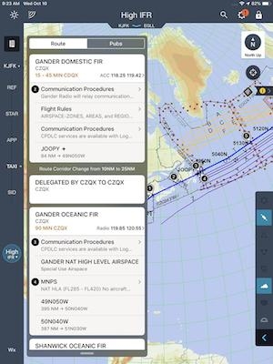
A new Organized Track Structure simplifies international, oceanic flight tracks by automatically plugging in route information based on entered arrival and departure airports, eliminating manual data entry.
Smart Notes, which analyze chronological and geospatial flight information to present key data points for pilots automatically, without the need for manual interaction.
New Standard Instrument Departure/Standard Arrival Routes (SID/STAR) chart data capabilities include own-ship depiction to highlight airplane location on the map in the busy terminal airspace environment. Pilots can now choose specific SID/STAR routing data to fit their unique flight plans and operation.

(Image provided with Boeing news release)

FMI: www.jeppesen.com/mobile

Advertisement

More News

ANN FAQ: Contributing To Aero-TV

How To Get A Story On Aero-TV News/Feature Programming How do I submit a story idea or lead to Aero-TV? If you would like to submit a story idea or lead, please contact Jim Campbel>[...]

ANN's Daily Aero-Linx (05.29.24)

Aero Linx: International Association of Professional Gyroplane Training (IAPGT) We are an Association of people who fly, build or regulate Gyroplanes, who have a dream of a single >[...]

ANN's Daily Aero-Term (05.29.24): NORDO (No Radio)

NORDO (No Radio) Aircraft that cannot or do not communicate by radio when radio communication is required are referred to as “NORDO.”>[...]

Airborne 05.28.24: Jump Plane Down, Starship's 4th, Vision Jet Problems

Also: uAvionix AV-Link, F-16 Viper Demo, TN National Guard, 'Staff the Towers' A Saturday afternoon jump run, originating from SkyDive Kansas City, went bad when it was reported th>[...]

ANN's Daily Aero-Term (05.30.24): Beyond Visual Line Of Sight (BVLOS)

Beyond Visual Line Of Sight (BVLOS) The operation of a UAS beyond the visual capability of the flight crew members (i.e., remote pilot in command [RPIC], the person manipulating th>[...]

blog comments powered by Disqus


Advertisement

Advertisement

Podcasts

Advertisement

© 2007 - 2024 Web Development & Design by Pauli Systems, LC