Wed, Apr 26, 2017
Only Park With Its Own Fleet Of UAVs For SAR Operations
An effort to locate two hikers who went missing in the Grand Canyon on April 15 involved the extensive use of drones owned by the National Park Service. But the aircraft were unable to locate the pair after several days of searching.
The hikers were identified in a NPS news release as Lou Ann Merrell, 62, and Jackson Standefer, 14.
On Saturday evening, April 15 the NPS received an alert from a personal locating beacon in a backcountry area of Grand Canyon National Park near the confluence of Tapeats Creek and Thunder River. An Arizona Department of Public Safety helicopter flew to the location where a hiking party reported two members of their party missing.
The party reported that Merrell and Standefer were last seen crossing Tapeats Creek below the confluence with Thunder River when they lost footing and were swept down Tapeats Creek.
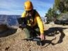
Beginning the morning of Sunday, April 16 and lasting through the end of the day Wednesday, April 19, the NPS searched extensively in both the Tapeats Creek area and the area of the Colorado River below the confluence with Tapeats Creek (approximately Colorado River Mile 134). Three teams (approximately 20 people total) searched ground areas along Tapeats Creek and the Colorado River each day staying in the field overnight. In order to cover areas that were inaccessible to the ground searchers, each day the NPS also utilized a helicopter and crew, an unmanned aerial system (UAS) and operator, and an inflatable motor raft and associated search team.

Arizona Department of Public Safety and Uintah County Search and Rescue (Uintah County Sheriff’s Department) assisted in the search.
The Associated Press reports that the Grand Canyon is the only national park that has a fleet of drones dedicated to SAR operations. There are five aircraft, and four certified operators are employed by the Park Service.
"Our historic model was to take the helicopter to look and see," said Grand Canyon chief ranger Matt Vandzura. Using a drone offers the ability to get "that same close look but without putting any people at risk. It has dramatically increased our ability to keep our people safe," he said.
In an incident last November, a drone was used to scout a landing area for a helicopter assisting the the recovery of the body of a man who drove off a cliff in the canyon and died. The helicopter was used to lift the car out of the canyon. Last December, the aircraft were used to locate the body of a woman who had jumped to her death in the canyon.
(NPS images)
More News
Runway Lead-in Light System Runway Lead-in Light System Consists of one or more series of flashing lights installed at or near ground level that provides positive visual guidance a>[...]
Aero Linx: Aviation Without Borders Aviation Without Borders uses its aviation expertise, contacts and partnerships to enable support for children and their families – at hom>[...]
Dave Juwel's Aviation Marketing Stories ITBOA BNITBOB ... what does that mean? It's not gibberish, it's a lengthy acronym for "In The Business Of Aviation ... But Not In The Busine>[...]
From 2010 (YouTube Version): Yeah.... This IS A Really Cool Job When ANN's Nathan Cremisino took over the lead of our Aero-TV teams, he knew he was in for some extra work and a lot>[...]
Also: Junkers A50 Heritage, Montaer Grows, Dynon-Advance Flight Systems, Vans' Latest Officially, the Carbon Cub UL and Rotax 916 iS is now in its 'market survey development phase'>[...]
 ANN's Daily Aero-Term (04.24.24): Runway Lead-in Light System

