Passive RADAR Altimeter, Flight Simulation Mode, and Real-Time Descent Profile Information In Latest Version
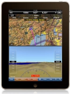
The latest version of WingX Pro7 features new Passive RADAR Altimeter technology for iPad and iPhone. The Passive RADAR Altimeter displays terrain elevation and the aircraft’s approximate AGL; together with Dynamic Terrain Overlays and Synthetic Vision, Hilton Software says WingX Pro7 continues to significantly reduce the risk of Controlled Flight Into Terrain (CFIT). WingX Pro7 Version 6.2 also adds Flight Simulation Mode that enables pilots to pre-fly an entire flight, portion of a flight, or an approach into an airport. Version 6.2’s Moving Map integrates Descent Profile Information that displays descent and landing information to the destination airport or runway touchdown zone.
“We are driven by our desire to increase aviation safety and efficiency," said Hilton Software CEO Dr. Hilton Goldstein. "Our new ‘no hardware, no wires’ Passive RADAR Altimeter solution is revolutionary in mobile aviation computing. WingX Pro7’s new Simulation Mode gives pre-flight a whole new meaning by driving all the pieces of WingX Pro7 including the Moving Map and Synthetic Vision. This enables pilots to simulate an approach into an airport while viewing and interacting with WingX Pro7 as though the approach was actually being flown. Instead of developing a simulator that runs on a desktop, we built flight simulation into the iPad. Another great feature in WingX Pro7 is the addition of Descent Profile Information that not only displays VNAV-like information, but also displays which runway the aircraft is approaching thereby reducing the risk of a runway incursion. We’ve also added tighter integration with Google Earth™ that enables pilots to view their planned
route in Google Earth.”
WingX Pro7 Version 6.2 is a free update for registered users and is available now for download from the App Store and iTunes. (Image provided by Hilton Software)
From 2023 (YouTube Version): Legacy of a Titan Robert (Bob) Anderson Hoover was a fighter pilot, test pilot, flight instructor, and air show superstar. More so, Bob Hoover was an i>[...]
Get The Latest in Aviation News NOW on Instagram Are you on Instagram yet? It's been around for a few years, quietly picking up traction mostly thanks to everybody's new obsession >[...]
Aero Linx: B-52H Stratofortress The B-52H Stratofortress is a long-range, heavy bomber that can perform a variety of missions. The bomber is capable of flying at high subsonic spee>[...]
Altimeter Setting The barometric pressure reading used to adjust a pressure altimeter for variations in existing atmospheric pressure or to the standard altimeter setting (29.92).>[...]
"Knowing that we play an active part in bettering people's lives is extremely rewarding. My team and I are very thankful for the opportunity to be here and to help in any way we ca>[...]
 Classic Aero-TV: Remembering Bob Hoover

