Wed, Mar 04, 2015
Eight Major Metro Areas, Gulf Of Mexico Included In First Release
Garmin is rolling out a new version of Garmin Pilot for iOS, which adds a suite of features tailored to helicopter operators. These features incorporate helicopter route charts throughout eight U.S. metropolitan areas, including the Gulf of Mexico. Additionally, the latest version of Garmin Pilot allows pilots to easily identify and document the highest obstacle along their flight plan route, which fulfills Part 135 Helicopter Emergency Medical Service (HEMS) requirements set forth by the FAA.
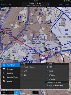
Helicopter Route Charts within Garmin Pilot provide detailed information applicable to the unique operations carried out by these operators. These three-color charts depict helicopter airways and routes, heliports with associated frequency and lighting capabilities, NAVAID information and obstructions. Additionally, pictorial symbols, roads and geographical features are notated on these charts for easier identification in urban areas with high concentrations of helicopter activity.
Garmin Pilot includes VFR and IFR Helicopter Route Charts for eight major metropolitan areas, including:
- Baltimore
- Boston
- Chicago
- Dallas-Ft.Worth
- Detroit
- Houston
- Los Angeles
- New York
Coverage for the Gulf of Mexico is also available, which includes offshore oil drilling platforms and more.
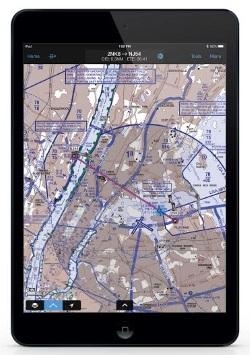
For helicopter air ambulance operators, rules recently established by the FAA requiring pilots to identify and document the highest obstacle along a planned route (§ 135.615), can now fulfill those requirements within Garmin Pilot. When entering a departure and destination airport pair, Garmin Pilot conveniently identifies the highest obstacle along the route of flight in mean sea level (MSL) and above ground level (AGL) within the Flight Plan page and notates the obstacle graphically on the moving map page.
The latest version of Garmin Pilot for iOS is available immediately as a free update, providing operators access to additional chart information tailored to helicopter operators and the opportunity to conveniently meet HEMS requirements.
(Images provided by Garmin)
FMI: www.garmin.com
More News
Airport Marking Aids Markings used on runway and taxiway surfaces to identify a specific runway, a runway threshold, a centerline, a hold line, etc. A runway should be marked in ac>[...]
"It is extremely difficult, if not impossible, for manned aircraft to see a drone while conducting crop-enhancing and other aerial applications at low altitudes and high speeds. We>[...]
Aero Linx: The Skyhawk Association The Skyhawk Association is a non-profit organization founded by former Skyhawk Pilots which is open to anyone with an affinity for the A-4 Skyhaw>[...]
“The T-54A benefits from an active Beechcraft King Air assembly line in Wichita, Kansas, where all required METS avionics and interior modifications are installed on the line>[...]
Aero Linx: Aerostar Owners Association The Association offers the Aerostar Owner a unique opportunity to tap an invaluable source of information concerning the care and feeding of >[...]
 ANN's Daily Aero-Term (04.28.24): Airport Marking Aids

