Sun, Mar 05, 2006
 Mercury Computer Systems, Inc. has
released VistaNav version 1.5, its multi-function flight display
system with synthetic vision technology. This latest release of the
VistaNav system integrates XM satellite weather information
including NEXRAD Precipitation and Cloud information, Live TFRs,
METAR Flight Rules Indicators (FRI), as well as detailed METAR and
TAF text information.
Mercury Computer Systems, Inc. has
released VistaNav version 1.5, its multi-function flight display
system with synthetic vision technology. This latest release of the
VistaNav system integrates XM satellite weather information
including NEXRAD Precipitation and Cloud information, Live TFRs,
METAR Flight Rules Indicators (FRI), as well as detailed METAR and
TAF text information.
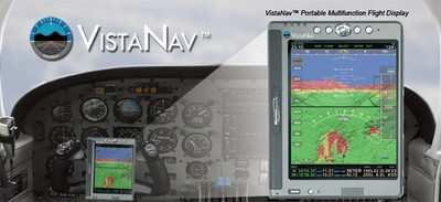
The VistaNav system provides the pilot with a complete portable
navigation solution including 3D Synthetic Vision,
Highway-in-the-Sky (HITS) Flight Path Guidance, 3D Terrain Views
and 3D Approach Display. In addition to its synthetic vision
features, VistaNav can display 2D navigation in either full or
split-screen formats.
"Adding XM weather to VistaNav’s three-dimensional
synthetic vision provides the pilot with a complete, portable
navigation solution and greatly enhances their ability to negotiate
both terrain and weather in challenging flight conditions," said
Philippe Roy, Director of the Visualization & Simulation Group,
Commercial Imaging and Visualization, Mercury Computer Systems.
"This combination of advanced 3D visualization technology and
state-of-the-art inertial navigation hardware delivers
unprecedented situational awareness to pilots in a portable cockpit
solution."
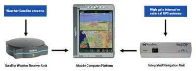
The VistaNav system includes an INU (Inertial Navigation Unit)
featuring 3D solid-state inertial sensors, a WAAS-enabled (Wide
Area Augmentation System) GPS receiver, and a Bluetooth®
wireless interface. The unit can be mounted in a number of places
inside an aircraft and communicates through a wireless interface
using a tablet PC mobile computing platform (MCP). The MCP has a
high-resolution 5"x 8" LCD display with a full navigation user
interface that allows pilots to manage all phases of flight, from
preparation to parking. The entire unit is powered by the aircraft
power supply and includes rechargeable batteries that will operate
for up to one hour in the event of an aircraft electrical failure.
Both the INU and MCP are designed to be removed or installed in an
aircraft in less than three minutes.
More News
Airport Marking Aids Markings used on runway and taxiway surfaces to identify a specific runway, a runway threshold, a centerline, a hold line, etc. A runway should be marked in ac>[...]
"It is extremely difficult, if not impossible, for manned aircraft to see a drone while conducting crop-enhancing and other aerial applications at low altitudes and high speeds. We>[...]
Aero Linx: The Skyhawk Association The Skyhawk Association is a non-profit organization founded by former Skyhawk Pilots which is open to anyone with an affinity for the A-4 Skyhaw>[...]
“The T-54A benefits from an active Beechcraft King Air assembly line in Wichita, Kansas, where all required METS avionics and interior modifications are installed on the line>[...]
Aero Linx: Aerostar Owners Association The Association offers the Aerostar Owner a unique opportunity to tap an invaluable source of information concerning the care and feeding of >[...]
 ANN's Daily Aero-Term (04.28.24): Airport Marking Aids

