Morpheus Uses Hazard Detection System To Land Safely In The Dark | Aero-News Network
Aero-News Network
RSS icon RSS feed
podcast icon MP3 podcast
Subscribe Aero-News e-mail Newsletter Subscribe

Airborne Unlimited -- Most Recent Daily Episodes

Episode Date

Airborne-Monday

Airborne-Tuesday

Airborne-Wednesday Airborne-Thursday

Airborne-Friday

Airborne On YouTube

Airborne-Unlimited-05.20.24

Airborne-Unlimited-05.28.24

Airborne-FlightTraining-05.29.24 Airborne-Unlimited-05.30.24

Airborne-Unlimited-05.24.24

Sun, Jun 01, 2014

Morpheus Uses Hazard Detection System To Land Safely In The Dark

ALHAT Demonstrated In Free-Flight Test At The Kennedy Space Center In FL

In a test this week, NASA demonstrated that it can land an unmanned spacecraft on a rugged planetary surface in the pitch dark. The free-flight test was the first of its kind for NASA's Autonomous Landing Hazard Avoidance Technology, or ALHAT.

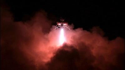
During testing, Morpheus -- an unmanned spacecraft capable of carrying 1,100 pounds of cargo -- powered its way up to more than 800 feet into the dark Florida sky at NASA's Kennedy Space Center using solely ALHAT's Hazard Detection System for guidance.

The Hazard Detection System, assisted by three light detection and ranging (lidar) sensors, located obstacles -- such as rocks and craters -- and safely landed on the lunar-like hazard field a quarter mile away from the NASA Center.

"The team has been striving for almost eight years to reach this point of testing the ALHAT system in a relevant space-flight-like environment on Morpheus," said Eric Roback, ALHAT flash lidar lead engineer.

During testing, the Hazard Detection System pointed its sensor at the hazard field and made a mosaic of flash lidar three dimensional range images encompassing the hazard field.

"The flash lidar performed very well, and we could clearly identify rocks as small as one foot  in size from the largest range that Morpheus could give us, which was approximately a quarter mile," Roback said. "With this sensor we could even find the safest landing site in a pitch black crater."

The Hazard Detection System then had to stitch the flash lidar images together to create a three dimensional map of the landing site, analyze the map and select the best landing sites. Shortly after, the Doppler lidar measured the vehicle's altitude and velocity to land precisely on the surface. The high-altitude laser altimeter provided data enabling the vehicle to land at the chosen landing site.

"Once this technology goes into service, the days of having to land 20 or 30 miles from where you really want to land for fear of the hazardous craters and rocks will be over," Roback said. "Then we can land near the truly interesting science and near the critical resources that will be needed for eventual colonization, and we can do it over and over again safely."

(Image provided by NASA)

FMI: http://alhat.jpl.nasa.gov

Advertisement

More News

ANN FAQ: Contributing To Aero-TV

How To Get A Story On Aero-TV News/Feature Programming How do I submit a story idea or lead to Aero-TV? If you would like to submit a story idea or lead, please contact Jim Campbel>[...]

ANN's Daily Aero-Linx (05.29.24)

Aero Linx: International Association of Professional Gyroplane Training (IAPGT) We are an Association of people who fly, build or regulate Gyroplanes, who have a dream of a single >[...]

ANN's Daily Aero-Term (05.29.24): NORDO (No Radio)

NORDO (No Radio) Aircraft that cannot or do not communicate by radio when radio communication is required are referred to as “NORDO.”>[...]

Airborne 05.28.24: Jump Plane Down, Starship's 4th, Vision Jet Problems

Also: uAvionix AV-Link, F-16 Viper Demo, TN National Guard, 'Staff the Towers' A Saturday afternoon jump run, originating from SkyDive Kansas City, went bad when it was reported th>[...]

ANN's Daily Aero-Term (05.30.24): Beyond Visual Line Of Sight (BVLOS)

Beyond Visual Line Of Sight (BVLOS) The operation of a UAS beyond the visual capability of the flight crew members (i.e., remote pilot in command [RPIC], the person manipulating th>[...]

blog comments powered by Disqus


Advertisement

Advertisement

Podcasts

Advertisement

© 2007 - 2024 Web Development & Design by Pauli Systems, LC