Duke Gets New Jet Ranger
Duke University's Pratt School of Engineering has purchased a
new Bell JetRanger helicopter to give the university and nation a
new platform of research sensors to bridge a gap in airborne
studies of natural and man-made environmental processes.

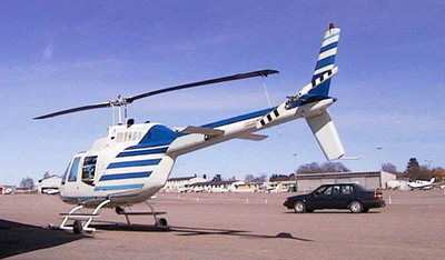
The turbine-powered Bell 206B-3, painted in Duke blue with black
stripes, arrived June 18, 2005, at the Burlington-Alamance Regional
Airport, where it is hangared with Duke Hospital's two Life Flight
helicopters. The engineering school aircraft was flown from Dallas,
where it was painted and outfitted with instrumentation by
Heli-Dyne Systems.
At the controls for the flight were Professor Roni Avissar,
chairman of civil and environmental engineering at the Pratt School
of Engineering, and Don Borg, a Bell Helicopter test pilot. Avissar
is a qualified helicopter pilot and will serve as copilot and
scientific systems manager on the craft's research missions.
Primary pilot on research missions will be Tim Sukow, site manager
for CJ Systems Aviation Group, which will maintain and operate the
helicopter along with Duke's Life Flight helicopters
By carrying specialized instruments attached to its nose and in
belly pods, the helicopter will be able to perform environmental
observations that are missed by high-flying and fast airplanes,
satellites, and balloons and sounding rockets. Avissar said such a
helicopter platform is currently not available anywhere for
research applications.
"The advantage of the helicopter is that it combines a slow
sampling speed, needed for many kinds of research, with a long
duration at the designated sampling area," Avissar said. "In
addition, a helicopter can fly safely at very low altitudes, and it
can operate in remote areas, even from ships, without requiring
long transit time."

The aircraft, which cost $1.3 million, is available to
researchers from other universities and institutions. Avissar said
several research teams are designing projects to utilize it.
"We consider this helicopter a national asset," said Pratt Dean
Kristina M. Johnson. "We are looking forward to helping researchers
across the country use this aircraft, or 'Helicopter Observation
Platform,' to better monitor and understand the influence of
natural and man-made modifications to local landscapes on the
environment."
The scientific sensors currently mounted on the craft's nose
include a sonic anemometer to measure very-high frequency,
three-dimensional turbulence at low flying speeds; an instrument to
measure water and carbon dioxide concentrations; a sensor to
measure three-dimensional wind, temperature and moisture content at
high flying speeds; and an aerosol counter to sample the air and
count the number of aerosols as well as measure their size
distribution.
Avissar said these are important meteorological observations
that are going to be needed for any scientific mission that will be
performed.
The first mission will be at a Duke Forest research site
designed to mimic effects that extra carbon dioxide from continued
industrial and vehicular emissions and other human activities will
have on typical forest ecosystems. Avissar said his studies of
carbon dioxide and water vapor above the site, combined with
findings in research towers at the site, will help in the
understanding of regional atmospheric carbon balances.

In addition, the helicopter is equipped with a satellite
navigation system that produces computer-generated,
three-dimensional images of the aircraft's position in relation to
the terrain below. Other instruments will be mounted on the
helicopter as needed.
 ANN's Daily Aero-Term (04.24.24): Runway Lead-in Light System
 ANN's Daily Aero-Linx (04.24.24)
 Aero-FAQ: Dave Juwel's Aviation Marketing Stories -- ITBOA BNITBOB
 Classic Aero-TV: Best Seat in The House -- 'Inside' The AeroShell Aerobatic Team
 Airborne Affordable Flyers 04.18.24: CarbonCub UL, Fisher, Affordable Flyer Expo


