European IFR Autorouting Now Available, As Well As Flight Plan Filing
Garmin International has announced several global enhancements and an expanded feature set for the Garmin Pilot application on Apple and Android mobile devices. European IFR autorouting and flight plan filing, improved airspace classifications, the wireless transfer of Jeppesen charts via Flight Stream 510 and more are available with the latest Garmin Pilot update for Apple mobile devices. Additionally, Garmin Pilot is making its debut as a comprehensive global navigation application for Android mobile devices, allowing customers to flight plan and view weather products throughout the world within the app. These series of global enhancements bring superior flight planning, filing, flight logging capabilities and more to Garmin Pilot customers within an all-inclusive, single application solution.
“As we continue to pack more features and capabilities into Garmin Pilot, we’re excited to provide our customers around the world with a premier application that they can utilize throughout every phase of flight,” said Carl Wolf, Garmin vice president of aviation sales and marketing. “As our global customer base continues to grow, we are excited to further expand worldwide flight planning capabilities, navigation and global weather coverage alongside game-changing integration, wireless connectivity and superior situational awareness tools so Garmin Pilot customers have access to the information they need to make the best informed decisions on the ground and in-flight.”
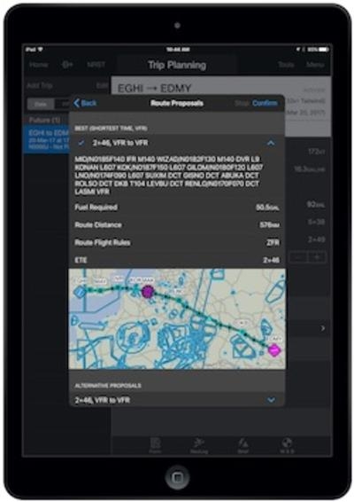
New Eurocontrol autorouting and flight plan filing within Garmin Pilot allows pilots to more easily file flight plans and fly throughout complex European airspaces. Within Garmin Pilot, autorouting is easily accessed in the trip planning page, allowing pilots to select the departure/destination airport pairs and areas to avoid. Routes are validated by Eurocontrol and then presented based on optimized criteria set by the pilot, including time, fuel required or altitude. Pilots can also browse alternate route proposals, select the most appropriate for their flight and easily activate the route within the Trip Planning page. For easier interpretation, pilots can also view the route on a map prior to filing and activating the flight plan.
Customers with a GTN 650/750 touchscreen navigator or the new G1000 NXi integrated flight deck with Flight Stream 510, can now take advantage of the wireless transfer of Jeppesen charts via Garmin Pilot on an Apple mobile device. Flight Stream 510 supports Database Concierge, the wireless transfer of aviation databases from the Garmin Pilot app to a compatible GTN navigator or the G1000 NXi. In addition to Database Concierge, Flight Stream 510 also enables two-way flight plan transfer between the GTN or the G1000 NXi and shares traffic, weather, GPS information, back-up attitude information and more between mobile devices and compatible avionics.
Additional features included within the Garmin Pilot app for Apple mobile devices:
- Easily access winds aloft data from the radial menu for easy viewing at a glance.
- Configurable radar color tables allow pilots to customize the color intensity of the radar returns based on preference.
- Pilots can access and utilize the scratch pad in split-screen mode.
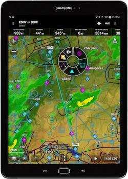
New for Android mobile devices, Garmin Pilot is now a full-featured navigation application for use throughout the world, including flight planning, global weather information, VFR flight plan filing and more. Rich, interactive maps integrated within Garmin Pilot offer worldwide coverage using Jeppesen NavData. Highly configurable maps also allow pilots to choose between track-up or north-up orientation depending on preference. Unique to Garmin Pilot, a radial menu provides easy on-screen access to perform common tasks in-flight or on the ground, including the option to create user waypoints, navigate direct-to, graphically edit flight plans, view weather conditions and airport information at a glance.
Global weather information including METARs, TAFs, AIRMETs, SIGMETs, NOTAMs and winds aloft may be displayed graphically as an overlay on the moving map page, within the airport information page and as a widget in split-screen mode. Additionally, radar and satellite imagery for Western Europe, Canada, Australia and the U.S. provide pilots with even more weather products to it’s easy to determine if precipitation or cloud cover will impact a particular flight.
Additional features also included within Garmin Pilot for Android mobile devices:
- FastFind, which incorporates predictive logic to suggest airports and waypoints using current GPS location so entering flight plan information is faster and easier.
- European Visual Reporting Points (VRPs), which can be overlaid on the moving map and be incorporated into a flight plan for easy navigation throughout Europe.
The newest release of Garmin Pilot for Apple and Android mobile devices are both available immediately. For new customers, Garmin Pilot is available from the Apple App Store and Google Play Store as a free download for the first 30 days. After the 30-day trial period, customers may purchase an annual subscription of Garmin Pilot starting at $74.99.
(Images provided with Garmin news release)
 ANN's Daily Aero-Term (04.25.24): Airport Rotating Beacon

