Honeywell's Popular Handheld Now Available For Helicopters | Aero-News Network
Aero-News Network
RSS icon RSS feed
podcast icon MP3 podcast
Subscribe Aero-News e-mail Newsletter Subscribe

Airborne Unlimited -- Most Recent Daily Episodes

Episode Date

Airborne-Monday

Airborne-Tuesday

Airborne-Wednesday Airborne-Thursday

Airborne-Friday

Airborne On YouTube

Airborne-Unlimited-04.22.24

Airborne-Unlimited-04.16.24

Airborne-FlightTraining-04.17.24 Airborne-AffordableFlyers-04.18.24

Airborne-Unlimited-04.19.24

Join Us At 0900ET, Friday, 4/10, for the LIVE Morning Brief.
Watch It LIVE at
www.airborne-live.net

Tue, Feb 23, 2010

Honeywell's Popular Handheld Now Available For Helicopters

Bendix/King By Honeywell AV8OR Provides Portable Weather, Traffic and GPS

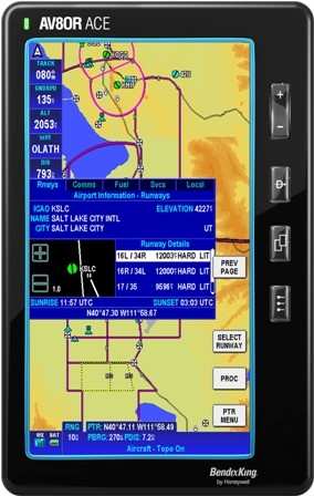
Honeywell announced Sunday at Heli-Expo 2010 that the AV8OR handheld Global Positioning System (GPS) is now available for helicopter operators.

"The AV8OR is a terrific addition to any helicopter, providing situational awareness of weather, terrain, traffic and airspace for very little cost," said Chad Cundiff, vice president, Crew Interface and Displays, Honeywell Aerospace. "For about $800, helicopter pilots get moving-map navigation with terrain awareness, which they can use on the ground or in the air, making every trip simple from door -- to air -- to door. The unit can also wirelessly interface to traffic and weather information."

The AV8OR is a portable touch-screen GPS for use in the car or in the air, with real-time weather capability, moving-map navigation and video-in capability. Its large 4.3-inch screen can display weather, from Honeywell's KDR 610 or the WxWorx portable receiver, and traffic from Zaon Flight Systems' XRX portable traffic receiver. The moving map display incorporates helicopter symbology, low altitude helicopter routes, helipads and controlled airspace.

The navigation database includes terrain shading and a SmartProfile view, enabling operators to see the terrain in the flight path of the helicopter.

With a $99 a year subscription, AV8OR offer daily updates on fuel pricing through Flight Guide, as well as on-field services, restaurants, taxi services and hotels. A dedicated online customer center provides operators with simple software updating capability.

The AV8OR is the first touch-screen handheld device developed for both aviation and automotive use, the first airway planner, the first to have multimedia capability and the first to have a Bluetooth phone interface -- all in one device.

FMI: www.honeywell.com

Advertisement

More News

ANN's Daily Aero-Term (04.24.24): Runway Lead-in Light System

Runway Lead-in Light System Runway Lead-in Light System Consists of one or more series of flashing lights installed at or near ground level that provides positive visual guidance a>[...]

ANN's Daily Aero-Linx (04.24.24)

Aero Linx: Aviation Without Borders Aviation Without Borders uses its aviation expertise, contacts and partnerships to enable support for children and their families – at hom>[...]

Aero-FAQ: Dave Juwel's Aviation Marketing Stories -- ITBOA BNITBOB

Dave Juwel's Aviation Marketing Stories ITBOA BNITBOB ... what does that mean? It's not gibberish, it's a lengthy acronym for "In The Business Of Aviation ... But Not In The Busine>[...]

Classic Aero-TV: Best Seat in The House -- 'Inside' The AeroShell Aerobatic Team

From 2010 (YouTube Version): Yeah.... This IS A Really Cool Job When ANN's Nathan Cremisino took over the lead of our Aero-TV teams, he knew he was in for some extra work and a lot>[...]

Airborne Affordable Flyers 04.18.24: CarbonCub UL, Fisher, Affordable Flyer Expo

Also: Junkers A50 Heritage, Montaer Grows, Dynon-Advance Flight Systems, Vans' Latest Officially, the Carbon Cub UL and Rotax 916 iS is now in its 'market survey development phase'>[...]

blog comments powered by Disqus


Advertisement

Advertisement

Podcasts

Advertisement

© 2007 - 2024 Web Development & Design by Pauli Systems, LC