Fri, Dec 10, 2004
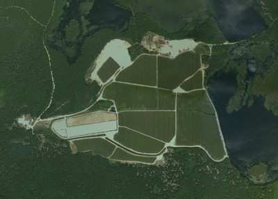
GeoVantage Provided High-Rez Digital Aerial Photography of
Ocean Spray Cranberry Bogs
 Ocean Spray’s cranberry
harvesting season drew to a close last month, made easier this year
with the use of GeoVantage’s high-resolution aerial imagery.
GeoVantage imaged cranberry bogs in two of Ocean Spray’s
major growing areas in Massachusetts and Quebec.
Ocean Spray’s cranberry
harvesting season drew to a close last month, made easier this year
with the use of GeoVantage’s high-resolution aerial imagery.
GeoVantage imaged cranberry bogs in two of Ocean Spray’s
major growing areas in Massachusetts and Quebec.
Ocean Spray has been implementing aerial photography since 1986.
They made the switch to digital imagery from conventional
film-based photos in 2002, when they selected GeoVantage as their
primary digital aerial imagery provider.
“We chose GeoVantage because of the quality of their imagery
product, and the competitive price that came along with it,”
explains Lyn DiBiase, Principal GIS Analyst at Ocean Spray,
“Our growing areas are located across the U.S. and Canada,
from New Jersey to British Columbia – GeoVantage’s
technology uniquely positions them to comprehensively deliver
imagery of any location. This makes my job that much easier because
I can work with a single provider for all my imagery and receive
consistent, high quality work.”
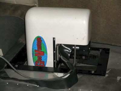
GeoVantage collects full color and near infrared digital imagery
simultaneously by implementing a fully digital workflow and a
multispectral camera system that is integrated with a global
positioning system (GPS) and inertial measurement unit (IMU). The
process enables imagery to be precisely georegistered and
orthorectified. GeoVantage’s systems are compact and
portable, which means they can be deployed rapidly anywhere in the
world and mounted on local aircraft for image capture.
DiBiase uses the resulting imagery in several ways. Imagery is
used to help on the business end – to map the land Ocean
Spray has under contract with growers who own the cooperative. By
determining the number of acres in production, Ocean Spray can
estimate the number of barrels growers will deliver in a harvest
and make business projections.
DiBiase also provides the imagery to individual growers to help
in their land management. The imagery can reveal drainage problems,
weed and insect infestation and when it may be time to renovate
certain areas. “Helping growers to better interpret and
utilize imagery data is one of my priorities. More and more, we can
apply new technologies to help improve and fine-tune our
production. The switch to digital imagery from film-based alone has
made my work more time-effective and accurate, reducing the chance
for operator error.”
More News
From 2023 (YouTube Version): Legacy of a Titan Robert (Bob) Anderson Hoover was a fighter pilot, test pilot, flight instructor, and air show superstar. More so, Bob Hoover was an i>[...]
Get The Latest in Aviation News NOW on Instagram Are you on Instagram yet? It's been around for a few years, quietly picking up traction mostly thanks to everybody's new obsession >[...]
Aero Linx: B-52H Stratofortress The B-52H Stratofortress is a long-range, heavy bomber that can perform a variety of missions. The bomber is capable of flying at high subsonic spee>[...]
Altimeter Setting The barometric pressure reading used to adjust a pressure altimeter for variations in existing atmospheric pressure or to the standard altimeter setting (29.92).>[...]
"Knowing that we play an active part in bettering people's lives is extremely rewarding. My team and I are very thankful for the opportunity to be here and to help in any way we ca>[...]
 Classic Aero-TV: Remembering Bob Hoover

