Mars Express Reveals Wind-Blown Deposits On Mars | Aero-News Network
Aero-News Network
RSS icon RSS feed
podcast icon MP3 podcast
Subscribe Aero-News e-mail Newsletter Subscribe

Airborne Unlimited -- Most Recent Daily Episodes

Episode Date

Airborne-Monday

Airborne-Tuesday

Airborne-Wednesday Airborne-Thursday

Airborne-Friday

Airborne On YouTube

Airborne-Unlimited-04.29.24

Airborne-NextGen-04.30.24

Airborne-Unlimited-05.01.24 Airborne-AffordableFlyers--05.02.24

Airborne-Unlimited-05.03.24

Wed, Feb 08, 2012

Mars Express Reveals Wind-Blown Deposits On Mars

Images Coming Back To ESA Show Stark Landscape

New images from ESA’s Mars Express show the Syrtis Major region on Mars. Once thought to be a sea of water, the region is now known to be a volcanic province dating back billions of years. Syrtis Major can be spotted from Earth even with relatively small telescopes – the near-circular dark area on the planet stretches over 1300 x 1500 km.

Christiaan Huygens discovered this area in 1659 and by repeated observations he used it to time the length of day on Mars. Early ideas held that it was a sea with a water level that rose and fell, causing the markings to change. Now, however, we know that the region is volcanic in origin, devoid of water and that the changes in its shape are due to dust and sand being blown around in the wind.

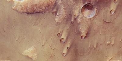
Newly released images of a part of Syrtis Major seen from ESA’s Mars Express orbiter show lava flows that flooded the older highland material, leaving behind buttes – isolated hills with steep sides that were too high to be affected. They can be identified by their lighter colours and their eroded state, and some even show ancient valleys on their flanks.
 
Individual lava flows, filled craters and partly-filled craters can be made out in the images. The prevailing wind direction can be seen from the dispersal of the lighter-toned dust and darker-toned sand in and around the craters and buttes. The smaller craters illustrate this clearly. The largest crater in the pictures has a small central peak and contains a small dune field of darker-toned dunes to the east of its floor.
 
The number and size of craters can be used to date surfaces in the Solar System because craters slowly accumulate as impacts occur over time. This information can be used to date the volcanic province and suggests an age of over 3 billion years.

FMI: www.esa.int/esaCP/SEM1NHTXXXG_index_0.html

Advertisement

More News

ANN's Daily Aero-Linx (05.02.24)

Aero Linx: Model Aeronautical Association of Australia MAAA clubs are about fun flying, camaraderie and community. For over 75 years, the MAAA has been Australia’s largest fl>[...]

ANN's Daily Aero-Term (05.02.24): Touchdown Zone Lighting

Touchdown Zone Lighting Two rows of transverse light bars located symmetrically about the runway centerline normally at 100 foot intervals. The basic system extends 3,000 feet alon>[...]

Aero-News: Quote of the Day (05.02.24)

“Discovery and innovation are central to our mission at Virgin Galactic. We’re excited to build on our successful record of facilitating scientific experiments in subor>[...]

ANN FAQ: Contributing To Aero-TV

How To Get A Story On Aero-TV News/Feature Programming How do I submit a story idea or lead to Aero-TV? If you would like to submit a story idea or lead, please contact Jim Campbel>[...]

NTSB Final Report: Cirrus Design Corp SR20

Student Pilot Reported That During Rotation, “All Of A Sudden The Back Of The Plane Kicked To The Right..." Analysis: The student pilot reported that during rotation, “>[...]

blog comments powered by Disqus


Advertisement

Advertisement

Podcasts

Advertisement

© 2007 - 2024 Web Development & Design by Pauli Systems, LC