Earth Observation Satellites, Capacity Building, Integrated Geo-Information Platform To Support The Kingdom Of Thailand’s Key Development Priorities
The Geo-Informatics and Space Technology Development Agency of Thailand (GISTDA) has selected Airbus as partner for its next-generation national geo-information system. The end-to-end system will make Thailand one of the few nations able to fully exploit geo-information for societal benefits. Fully in line with Thailand’s 4.0 policy, the THEOS-2 program will constitute a major milestone in the development of Space in the Eastern Economic Corridor and its Digital Park.
As part of the contract, a comprehensive capacity building program will involve Thai engineers in the development of an integrated geo-information system, ground segment and two Earth observation satellites: a very high-resolution and a small satellite system. The small satellite system from Airbus’ subsidiary SSTL will be assembled and tested in-country by Thai engineers to deliver technology transfer and involve local suppliers. This will be complemented by an extensive training scheme capitalizing on Airbus’ comprehensive geo-intelligence expertise, and will further develop Thailand’s geo-spatial industry.
“We are very pleased to be working with Airbus to jointly develop an innovative end-to-end geo-information platform that will become a national centre of excellence,” said Dr. Anond Snidvongs, Executive Director of GISTDA. “The platform will host and exploit multi-source data in an interoperable and integrated manner. The resulting insights will be key sources of information for Thai leaders and will help them deliver Actionable Intelligence Policy (AIP): tools for area-based management and decision-making.”
"Many users will access the system, from policy-makers to local users," said Snidvongs. "Ultimately, THEOS-2 will be leveraged to develop Thailand national skills in the whole Space value chain.”
“Being selected by GISTDA for the THEOS-2 program, Airbus is continuing the successful relationship developed with THEOS-1, and we are of course very honoured by GISTDA’s continued confidence in us,” said Nicolas Chamussy, Head of Space Systems at Airbus. “With our unrivalled expertise across the entire Earth observation value chain, we are in an excellent position to support an ambitious and determined organisation like GISTDA to establish an all-encompassing geo-information system for the benefit of the Kingdom of Thailand.”
From the early stages of the program, GISTDA will feed its geo-information system with satellite imagery collected by the Airbus constellation of optical and radar Earth observation satellites Pléiades, SPOT, TerraSAR-X and TanDEM-X, as well as other sources of data.
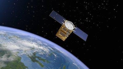
An optical satellite system delivering 0.5 m ground resolution imagery, THEOS-2 is based on Airbus’ innovative, flight-proven AstroBus-S satellite. Scheduled to be launched in 2020, it will secure the service continuity of THEOS-1, an Airbus-built satellite launched in 2008, which continues to deliver high quality imagery four years after its expected end of life. With the AstroBus-S satellite, Thailand is joining a small circle of nations with sovereign access to very high-resolution geostrategic information.
(Image provided with Airbus news release)