Airplane Broke Up In Flight In July, 2016
The NTSB has released its factual report from an accident which occurred on July 21, 2016 in which a Piper PA-30 Twin Comanche broke up in flight near Plainfield, IL while enroute to Eagle River Union Airport (KEGV), Eagle River, WI.
The flight originated at Upper Cumberland Regional Airport (KSRB), near Sparta, TN. The commercial pilot was fatally injured. The airplane was registered to and operated by the pilot. Day visual meteorological conditions were reported near the accident site about the time of the accident and no flight plan was filed for the flight.
According to fueling records, the airplane was fueled with 73.61 gallons of 100 low lead aviation gasoline at KSRB on July 21, 2016. The airplane taxied out for departure about 0841. Shortly after takeoff, the pilot established contact with an FAA air traffic controller and requested visual flight rules flight following to KEGV. Flight following service availability is based on controller workload. The flight was issued a discrete transponder code (1647) and proceeded toward the destination. At 1039, the pilot established contact with the Chicago, Illinois, Air Route Traffic Control Center. At 1104, as the airplane neared Class B airspace, the controller terminated flight following services tofor the airplane, instructed the pilot to change the transponder code to VFR (1200), and provided another frequency on which the pilot could attempt to reinstate flight following. The pilot contacted the next controller at 1105 and provided his previously-assigned discrete transponder code of 1647. The controller
could not identify the airplane using that code and provided another ATC frequency to the pilot. The next controller was also unable to identify the airplane using the 1647 transponder code and instructed the pilot to remain clear of the Class B airspace.
A radar performance study indicated that, until about 1108, the airplane was travelling on a heading about 320° (true) at an altitude of 8,500 ft mean sea level (msl) and a groundspeed about 150 kts. About 1108:23, the airplane initiated a climb, during which its equivalent airspeed (groundspeed adjusted for wind conditions) began to decrease and its angle of attack increased to nearly 20° nose up. The airplane reached 10,300 ft about 1111:10. Shortly thereafter, it reached its lowest equivalent airspeed about 48 knots, then entered a series of descending turns. The final radar target was recorded about 1112:37, at an altitude of 2,200 ft and an equivalent airspeed of 211 kts.
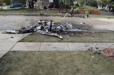
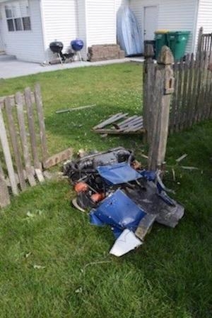
Witnesses saw sections of the airplane descend. Sections of the airplane impacted multiple locations in the Plainfield area, one of which caught fire and ignited a nearby building. No ground injuries were reported. Witnesses reported weather in the area consistent with a rapidly-forming thunderstorm.
A review of recovered maintenance records showed that the airplane's most recent annual inspection was completed on September 22, 2015. An airplane logbook endorsement, dated November 1, 2015, indicated that the airplane had repairs completed to include the replacement of its left side center wing leading edge skin and lower center wing skin, and replacement of its left aileron skin.
According to records from Lockheed Martin Flight Service, the pilot requested a weather briefing for the flight to SRB, but did not obtain a weather briefing for the accident flight.
A National Transportation Safety Board (NTSB) Senior Meteorologist gathered weather data and produced a Weather Study in reference to this investigation. The study is appended to the docket material associated with this investigation. The study, in part, included local Aviation Routine Weather Reports (METAR) at the Joliet Regional Airport (JOT), near Joliet, Illinois.
At 0753, the Storm Prediction Center issued a Convective Outlook that identified "marginal" risk for the accident site, defined as, "isolated severe thunderstorms possible, limited in duration and/or coverage and/or intensity."
At 1115, the recorded weather at JOT included wind from 230° at 7 kts, visibility 10 statute miles, sky condition broken clouds at 2,100 ft, temperature 32° C, dew point 27° C, and an altimeter setting of 30.10 inches of mercury.
At 1135, the recorded weather at JOT included wind from 210° at 3 kts, visibility 10 statute miles, present weather thunderstorms in the vicinity, sky condition scattered clouds at 2,100 ft, broken clouds at 4,200 ft, broken clouds at 5,000 ft, temperature 31° C; dew point 27° C, and an altimeter setting of 30.10 inches of mercury.
The meteorologist discovered that local observation stations had a lightning detection system installed. The lightning detection sensor provides cloud-to-cloud, cloud-to-ground and cloud-to-air lighting detection. Publicly disseminated METARs from the local stations were made every 20 minutes, and lightning must be detected within the previous one minute of the report in order to trigger an appropriate thunderstorm and/or lightning indication in the publicly-disseminated METAR. No special reports are issued from these observation stations, though internal reports are generated every minute, which are available via radio and phone.
Weather imagery depicted relatively clear skies at the accident location about 20 minutes before the accident time. Cumulus-type clouds were recorded to the west through north of the accident location at 1052. Subsequent imagery identified cumulus type clouds over the accident location about the accident time. Weather radar imagery identified reflectivity features consistent with convection immediately adjacent to the airplane's position immediately before the accident time.
There were no Airmen's Meteorological Information advisories active for the accident location at the accident time below 25,000 ft and there were no convective or non-convective Significant Meteorological Information advisories active for the accident location at the accident time. There were no Center Weather Advisories (CWA) or Meteorological Impact Statements issued by the Center Weather Service Unit at the Chicago Air Route Traffic Control Center that were active for the area where the accident occurred at the accident time. However, at 1140, a CWA was issued for an isolated thunderstorm with a diameter of 20 miles about 9 miles east-southeast of JOT moving from 280° at 15 knots. There were no publicly-disseminated pilot reports made within 2 hours of the accident time and 50 miles of the accident location.
The 1000 North American Mesoscale (NAM) model sounding for the accident location was retrieved from the National Oceanic and Atmospheric Administration's (NOAA) Air Resources Laboratory. The sounding indicated the most-unstable Convective Available Potential Energy (CAPE) parameter was 4,207 Joules/kilogram (from 995 hPa). The maximum vertical velocity (MVV) for this atmosphere was calculated as 92 meters/second (about 18,100 ft per minute). Additionally, the Downdraft CAPE (DCAPE) was measured at 1,194 Joules/kilogram. CAPE is a measure of the amount of energy available for convection and is directly related to the maximum potential vertical speed within an updraft; higher values indicate greater potential for severe weather. A value of 471 Joules/kilogram would be considered relatively weak. The DCAPE can be used to estimate the potential strength of rain-cooled downdrafts within thunderstorm convection, and is similar to CAPE. Larger DCAPE values are associated with stronger downdrafts. A value of
736 Joules/kilogram would be considered a moderate value.
(Images from NTSB accident docket)
 Airbus Racer Helicopter Demonstrator First Flight Part of Clean Sky 2 Initiative

