FAA Certifies G500H For MD 500 Series Aircraft | Aero-News Network
Aero-News Network
RSS icon RSS feed
podcast icon MP3 podcast
Subscribe Aero-News e-mail Newsletter Subscribe

Airborne Unlimited -- Most Recent Daily Episodes

Episode Date

Airborne-Monday

Airborne-Tuesday

Airborne-Wednesday Airborne-Thursday

Airborne-Friday

Airborne On YouTube

Airborne-Unlimited-04.29.24

Airborne-NextGen-04.30.24

Airborne-Unlimited-05.01.24 Airborne-AffordableFlyers--05.02.24

Airborne-Unlimited-05.03.24

Tue, Mar 06, 2012

FAA Certifies G500H For MD 500 Series Aircraft

Installation Is Available As OEM, Retrofit

MD Helicopters has received FAA certification of the Garmin G500H electronic flat panel displays. The G500H system, approved under the Type Certificate of the MD 500, is available for production and  retrofit installation in the MD 500E, MD 530F and MD 520N helicopters. Installation is immediately available for production aircraft, and for retrofit installations performed at the MD Factory Service Center in Mesa, Arizona. Kits will soon be available for installation at either MD Authorized Service Centers or at Garmin Authorized Dealer Network facilities.

“Upgrading the flight display systems and the single engine cockpit was a priority for the Company, said Lynn Tilton, CEO of MD Helicopters. This offering allows our single-engine customer base to enhance their favored airframe with the revolutionary pilot-centered avionics tools Garmin offers.”

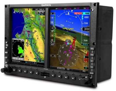
The Primary Flight Display (PFD) and Multi Function Display (MFD) provide easy visual scanning and interpretation. Garmin’s G500H dual-screen electronic flight display offers an affordable flight solution that meets the needs of the most demanding helicopter missions. The PFD screen shows attitude, airspeed, altitude, climb rate and course/heading information — while the MFD screen provides detailed moving-map graphics depicting the helicopter’s current position in relation to ground features, chart data, navaids and flight plan routings. Optional Synthetic Vision Technology (SVT) provides unparalleled situational awareness crucial to helicopter operations. To help monitor location on unfamiliar airports, the G500H comes with preloaded geo-referenced SafeTaxi diagrams for over 900 U.S. airports. A simple-to-navigate interface is accessed by a rotary knob for data entry and soft-keys for mode selection. A front-loading SD card slot makes it easy to add data and make updates. (Image provided by Garmin)

FMI: www.mdhelicopters.com

Advertisement

More News

ANN's Daily Aero-Linx (05.02.24)

Aero Linx: Model Aeronautical Association of Australia MAAA clubs are about fun flying, camaraderie and community. For over 75 years, the MAAA has been Australia’s largest fl>[...]

ANN's Daily Aero-Term (05.02.24): Touchdown Zone Lighting

Touchdown Zone Lighting Two rows of transverse light bars located symmetrically about the runway centerline normally at 100 foot intervals. The basic system extends 3,000 feet alon>[...]

Aero-News: Quote of the Day (05.02.24)

“Discovery and innovation are central to our mission at Virgin Galactic. We’re excited to build on our successful record of facilitating scientific experiments in subor>[...]

ANN FAQ: Contributing To Aero-TV

How To Get A Story On Aero-TV News/Feature Programming How do I submit a story idea or lead to Aero-TV? If you would like to submit a story idea or lead, please contact Jim Campbel>[...]

NTSB Final Report: Cirrus Design Corp SR20

Student Pilot Reported That During Rotation, “All Of A Sudden The Back Of The Plane Kicked To The Right..." Analysis: The student pilot reported that during rotation, “>[...]

blog comments powered by Disqus


Advertisement

Advertisement

Podcasts

Advertisement

© 2007 - 2024 Web Development & Design by Pauli Systems, LC