SRI International CubeSat Launched To Investigate Ionospheric Turbulence | Aero-News Network
Aero-News Network
RSS icon RSS feed
podcast icon MP3 podcast
Subscribe Aero-News e-mail Newsletter Subscribe

Airborne Unlimited -- Most Recent Daily Episodes

Episode Date

Airborne-Monday

Airborne-Tuesday

Airborne-Wednesday Airborne-Thursday

Airborne-Friday

Airborne On YouTube

Airborne-Unlimited-04.29.24

Airborne-Unlimited-04.23.24

Airborne-Unlimited-04.24.24 Airborne-FltTraining-04.25.24

Airborne-Unlimited-04.26.24

Fri, Dec 21, 2018

SRI International CubeSat Launched To Investigate Ionospheric Turbulence

Phenomenon Can Disturb Essential Radio Communications

An SRI International miniature satellite (CubeSat) space-weather mission, the Ionospheric Scintillation Explorer (ISX), was launched into space on December 15 to investigate regions of natural ionospheric turbulence. These patches of disturbed ions and electrons corrupt radio transmissions and wreak havoc on essential Earth and space-based communication and navigation channels.

"Our understanding for the life cycle of these turbulent patches is quite limited, as we lack means to regularly probe their 3D structure," said Hasan Bahcivan, Ph.D, research physicist and SRI principal investigator for the ISX mission. "To date, we have little insight into how far the disturbed patches extend along Earth's geomagnetic field and have limited options to adapt our communication systems to operate within these regions."

Dr. Bahcivan's novel approach for the ISX investigation is to examine thousands of digital terrestrial television (DTT) channels known to penetrate the patch regions for evidence of signal corruption. Because the powerful ground-based DTT transmitters have fixed locations and stable operating frequencies, they form a global network of signals ideally suited for imaging the internal structure of the disturbed ionospheric patches. As the ISX orbits, it will receive signals from multiple DTT transmitters to form a 3D image of emergent disturbances, an observational technique similar to a medical CAT scan.

The DTT scan technique relies on a multi-channel digital radio receiver developed at SRI International specifically for the ISX space weather mission. The design and operation of this receiver is based on two prior NSF space weather missions, the Radio Auroral Explorers (RAX-1 and RAX-2), which discovered similar ionospheric turbulence patches driven by the aurora in Earth's polar regions.  SRI researchers have also designed, assembled, and successfully flown radio and ultraviolet sensors on space-weather research missions for NASA, NSF, and the U.S. Air Force.

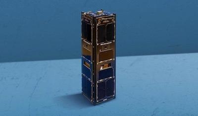
The SRI International ISX receiver is installed in a 3-liter miniature satellite (CubeSat) designed by students at the California Polytechnic State University, San Luis Obispo.  "The ISX mission continues the NSF's commitment to visionary PI-guided space weather research enabled by student spacecraft designers," said S. Irfan Azeem, Ph.D., program director for Space Weather Research and CubeSat program director for the ISX mission. The CubeSat is the eleventh spacecraft designed at Cal Poly and is the eleventh space research mission launched since 2008 with support from the Atmospheric and Geospace Sciences division at NSF.

The mission is supported by a grant from the National Science Foundation (NSF).

(Image provided with SRI International news release)

FMI: www.sri.com

Advertisement

More News

Unfortunate... ANN/SportPlane Resource Guide Adds To Cautionary Advisories

The Industry Continues to be Rocked By Some Questionable Operations Recent investigations and a great deal of data has resulted in ANN’s SportPlane Resource Guide’s rep>[...]

ANN FAQ: Turn On Post Notifications

Make Sure You NEVER Miss A New Story From Aero-News Network Do you ever feel like you never see posts from a certain person or page on Facebook or Instagram? Here’s how you c>[...]

ANN's Daily Aero-Term (04.29.24): Visual Approach Slope Indicator (VASI)

Visual Approach Slope Indicator (VASI) An airport lighting facility providing vertical visual approach slope guidance to aircraft during approach to landing by radiating a directio>[...]

ANN's Daily Aero-Term (04.28.24): Airport Marking Aids

Airport Marking Aids Markings used on runway and taxiway surfaces to identify a specific runway, a runway threshold, a centerline, a hold line, etc. A runway should be marked in ac>[...]

ANN's Daily Aero-Linx (04.28.24)

Aero Linx: The Skyhawk Association The Skyhawk Association is a non-profit organization founded by former Skyhawk Pilots which is open to anyone with an affinity for the A-4 Skyhaw>[...]

blog comments powered by Disqus


Advertisement

Advertisement

Podcasts

Advertisement

© 2007 - 2024 Web Development & Design by Pauli Systems, LC