Boeing Delta II Keeps GPS Constellation Healthy | Aero-News Network
Aero-News Network
RSS icon RSS feed
podcast icon MP3 podcast
Subscribe Aero-News e-mail Newsletter Subscribe

Airborne Unlimited -- Most Recent Daily Episodes

Episode Date

Airborne-Monday

Airborne-Tuesday

Airborne-Wednesday Airborne-Thursday

Airborne-Friday

Airborne On YouTube

Airborne-Unlimited-04.29.24

Airborne-NextGen-04.30.24

Airborne-Unlimited-05.01.24 Airborne-AffordableFlyers--05.02.24

Airborne-Unlimited-05.03.24

Fri, Jun 25, 2004

Boeing Delta II Keeps GPS Constellation Healthy

Satellite Safely In Orbit

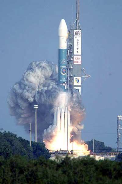
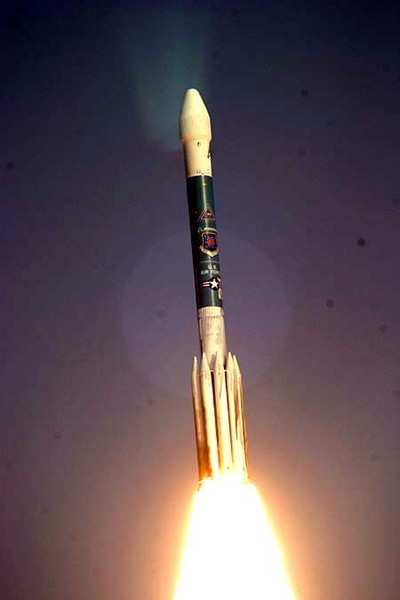
A Boeing Delta II rocket successfully deployed to space a replacement satellite for the US Air Force’s Global Positioning System (GPS) Wednesday.

The launch of GPS IIR-12 aboard a three-stage Delta II launch vehicle occurred from Space Launch Complex 17B, Cape Canaveral Air Force Station, Fla., at 6:54 p.m. EDT. Following a 26-minute flight, the spacecraft was injected to a transfer orbit from a descending deployment flight profile.

Once operational, GPS IIR-12 will support US military missions and provide a wide variety of civilian directional guidance services.

"As our government customer increases the use of space-based systems to support military efforts around the world, I am very proud of our Delta team as we continue to produce and launch vehicles that provide our nation with an extremely reliable means of deploying these critically important systems to orbit," said Will Trafton, vice president and general manager, Boeing Expendable Launch Syste

Today’s launch marks the 58th consecutive successful mission carried out by the Boeing Delta II.

The Delta II 7925-9.5 configuration vehicle used for the GPS IIR-12 mission was powered by a Boeing Rocketdyne RS-27A main engine with nine Alliant Techsystems strap-on solid rocket boosters, and used a nine-and-a-half-foot diameter Boeing-built composite payload fairing to encapsulate the spacecraft.

GPS IIR-12 joins the GPS constellation that consists of 24 Block II version spacecraft, of which Boeing has launched all satellites for this phase of the program.

GPS provides military and civilian users three-dimensional position location data in longitude, latitude and elevation as well as precise time and velocity.

The US military uses GPS to support operations involving aircraft, ships, land vehicles and ground personnel using handheld devices. Other applications such as mapping, aerial refueling and rendezvous, geodetic surveys, and search and rescue operations also benefit from the system.

The next Delta launch is NASA’s Aura mission aboard a Delta II planned for July from Vandenberg Air Force Base (CA).

FMI: www.boeing.com

Advertisement

More News

ANN's Daily Aero-Linx (05.02.24)

Aero Linx: Model Aeronautical Association of Australia MAAA clubs are about fun flying, camaraderie and community. For over 75 years, the MAAA has been Australia’s largest fl>[...]

ANN's Daily Aero-Term (05.02.24): Touchdown Zone Lighting

Touchdown Zone Lighting Two rows of transverse light bars located symmetrically about the runway centerline normally at 100 foot intervals. The basic system extends 3,000 feet alon>[...]

Aero-News: Quote of the Day (05.02.24)

“Discovery and innovation are central to our mission at Virgin Galactic. We’re excited to build on our successful record of facilitating scientific experiments in subor>[...]

ANN FAQ: Contributing To Aero-TV

How To Get A Story On Aero-TV News/Feature Programming How do I submit a story idea or lead to Aero-TV? If you would like to submit a story idea or lead, please contact Jim Campbel>[...]

NTSB Final Report: Cirrus Design Corp SR20

Student Pilot Reported That During Rotation, “All Of A Sudden The Back Of The Plane Kicked To The Right..." Analysis: The student pilot reported that during rotation, “>[...]

blog comments powered by Disqus


Advertisement

Advertisement

Podcasts

Advertisement

© 2007 - 2024 Web Development & Design by Pauli Systems, LC