CAP Radar, Cell Phone Analysis Teams Narrow Search For Idaho Accident Site | Aero-News Network
Aero-News Network
RSS icon RSS feed
podcast icon MP3 podcast
Subscribe Aero-News e-mail Newsletter Subscribe

Airborne Unlimited -- Most Recent Daily Episodes

Episode Date

Airborne-Monday

Airborne-Tuesday

Airborne-Wednesday Airborne-Thursday

Airborne-Friday

Airborne On YouTube

Airborne-Unlimited-04.29.24

Airborne-Unlimited-04.23.24

Airborne-Unlimited-04.24.24 Airborne-FltTraining-04.25.24

Airborne-Unlimited-04.26.24

Sat, Dec 07, 2013

CAP Radar, Cell Phone Analysis Teams Narrow Search For Idaho Accident Site

Searching For Missing Bonanza Believed Down In Rugged Terrain

When a single engine plane goes down in the continental U.S., Civil Air Patrol’s cell phone and radar tracking experts are certain to be involved. Their mission – reduce the search area from thousands of square miles to the actual crash site or within a couple of square miles – is urgent, because reducing the crash-to-rescue time saves lives.

Searchers for a single-engine airplane believed downed in snowy, mountainous central Idaho are relying on CAP’s cutting-edge radar analysis as they try to find the California family of five aboard the missing Beech Bonanza.

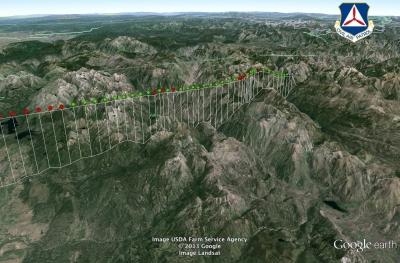
Lt. Col. John Henderson of CAP’s 10-member National Radar Analysis Team was able to detect and map the plane’s radar track until just before the aircraft apparently began its descent Sunday. Piloted by Dale Smith of San Jose, CA, and carrying his son, his son’s wife, his daughter and her fiancé, the Bonanza was bound from Baker City, Ore, to Butte, MT. The Radar Analysis Team worked hand-in-hand with CAP’s two-man Cell Phone Forensics Team, and everyone’s analysis of the clues and data led to the same conclusions. “The cell phone data stopped about a minute before the plane dropped off of radar,” said Maj. Justin Ogden, a CAP cell phone forensics expert. “Our data correlated with the radar analysis team’s regarding the plane’s location at that time.”

CAP’s radar analysis track record is impressive. “It can be extremely accurate,” said Henderson. “Over 90 percent of the time we narrow the search area based on forensics information. We’ve come within 65 feet of where a crash occurred and sometimes miles. It depends on the radar environment.”

In 13 years, Henderson estimated, he’s participated in more than 600 missions with “well over 150 finds” and about 45 lives saved – but the Idaho mission involves some serious obstacles. The Bonanza was flying above extremely rugged, snow-covered terrain, both elements that can interfere with radar tracking. As a result, the track ended when it was still “well above ground,” said Henderson, a CAP volunteer member for more than 20 years.

That means the plane “could have traveled miles” before landing, he said. “We just don’t know what he did after we lost radar coverage.”

“How he crashed and the snowfall are huge factors,” he said, adding, “the snowfall can cover the crash site.”

Without radar analysis or cell phone forensics searches for a downed plane can prove daunting. “Pilots would be just flying around trying to spot wreckage,” Henderson said.

Idaho Wing Commander Col. Mike Vorachek said CAP is providing high-bird communication links today, while four helicopters searched for the missing plane. “We’re yielding our airspace to the helicopters, because they can get so much lower,” he said. On Tuesday and Wednesday, Vorachek said CAP aircrews flew more than 20 hours over the search area.

As of Friday, the aircraft had not been located.

(Image provided by the CAP)

FMI: www.gocivilairpatrol.com

Advertisement

More News

Unfortunate... ANN/SportPlane Resource Guide Adds To Cautionary Advisories

The Industry Continues to be Rocked By Some Questionable Operations Recent investigations and a great deal of data has resulted in ANN’s SportPlane Resource Guide’s rep>[...]

ANN FAQ: Turn On Post Notifications

Make Sure You NEVER Miss A New Story From Aero-News Network Do you ever feel like you never see posts from a certain person or page on Facebook or Instagram? Here’s how you c>[...]

ANN's Daily Aero-Term (04.29.24): Visual Approach Slope Indicator (VASI)

Visual Approach Slope Indicator (VASI) An airport lighting facility providing vertical visual approach slope guidance to aircraft during approach to landing by radiating a directio>[...]

ANN's Daily Aero-Term (04.28.24): Airport Marking Aids

Airport Marking Aids Markings used on runway and taxiway surfaces to identify a specific runway, a runway threshold, a centerline, a hold line, etc. A runway should be marked in ac>[...]

ANN's Daily Aero-Linx (04.28.24)

Aero Linx: The Skyhawk Association The Skyhawk Association is a non-profit organization founded by former Skyhawk Pilots which is open to anyone with an affinity for the A-4 Skyhaw>[...]

blog comments powered by Disqus


Advertisement

Advertisement

Podcasts

Advertisement

© 2007 - 2024 Web Development & Design by Pauli Systems, LC