Garmin Expands Global Aviation Charting Capabilities | Aero-News Network
Aero-News Network
RSS icon RSS feed
podcast icon MP3 podcast
Subscribe Aero-News e-mail Newsletter Subscribe

Airborne Unlimited -- Most Recent Daily Episodes

Episode Date

Airborne-Monday

Airborne-Tuesday

Airborne-Wednesday Airborne-Thursday

Airborne-Friday

Airborne On YouTube

Airborne-Unlimited-04.29.24

Airborne-NextGen-04.30.24

Airborne-Unlimited-05.01.24 Airborne-AffordableFlyers--05.02.24

Airborne-Unlimited-05.03.24

Fri, Dec 14, 2012

Garmin Expands Global Aviation Charting Capabilities

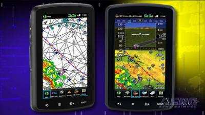
Releases European VFR, IFR Charts For aera Portable Devices

Garmin has released European VFR and IFR charts for the aera 795/796 aviation portable GPS, with VFR data sourced directly from Deutsche Flugsicherung (DFS). These charts are the most recent addition to the growing list of worldwide aviation charting products available from Garmin.

“Pilots have flown behind DFS paper charts for years, but the ability to display the charts electronically is something our European customers have been asking for. We’ve listened to that feedback and have made significant investments over the last year to expand our electronic chart offerings for customers worldwide,” said Carl Wolf, Garmin’s vice president of aviation sales and marketing. “Having information available electronically in the cockpit offers pilots more immediate access to the information they need to make good decisions.”

Earlier this year, Garmin also introduced European VFR terminal charts, or Bottlang charts, from Jeppesen for the aera 795/796, containing colored visual approach, landing and area charts, as well as general-and country-related text sections such as Regulations, Communications, Meteorology, Aerodrome Directory and more for the planning and execution of flights within Europe under Visual Flight Rules.

Additionally, Garmin recently expanded its SafeTaxi database, which now includes geo-referenced airport diagrams for over 1,000 U.S. airports, nearly 500 European airports and over 250 Canadian airports. This database is complemented by an electronic AC-U-KWIK global airport directory that includes information about nearly 8,000 airports worldwide.

The new European VFR and IFR charts for the aera 795/796 are available as a combination subscription for $410. Customers may purchase only the IFR charts for $155 for an annual subscription. VFR charts are available as a one-time purchase of a single country ranging from $32 to $90, or as a one-time purchase for all of Europe for $205.

FMI: www.flyGarmin.com

Advertisement

More News

ANN's Daily Aero-Linx (05.02.24)

Aero Linx: Model Aeronautical Association of Australia MAAA clubs are about fun flying, camaraderie and community. For over 75 years, the MAAA has been Australia’s largest fl>[...]

ANN's Daily Aero-Term (05.02.24): Touchdown Zone Lighting

Touchdown Zone Lighting Two rows of transverse light bars located symmetrically about the runway centerline normally at 100 foot intervals. The basic system extends 3,000 feet alon>[...]

Aero-News: Quote of the Day (05.02.24)

“Discovery and innovation are central to our mission at Virgin Galactic. We’re excited to build on our successful record of facilitating scientific experiments in subor>[...]

ANN FAQ: Contributing To Aero-TV

How To Get A Story On Aero-TV News/Feature Programming How do I submit a story idea or lead to Aero-TV? If you would like to submit a story idea or lead, please contact Jim Campbel>[...]

NTSB Final Report: Cirrus Design Corp SR20

Student Pilot Reported That During Rotation, “All Of A Sudden The Back Of The Plane Kicked To The Right..." Analysis: The student pilot reported that during rotation, “>[...]

blog comments powered by Disqus


Advertisement

Advertisement

Podcasts

Advertisement

© 2007 - 2024 Web Development & Design by Pauli Systems, LC