Wed, Oct 24, 2007
Aircraft Equipped With Thermal Imaging Sensors
In response to a request from the California Office of Emergency
Services and the National Interagency Fire Center, NASA is flying
an aircraft equipped with sophisticated infrared imaging equipment
Wednesday to assist firefighters battling several of the Southern
California wildfires.
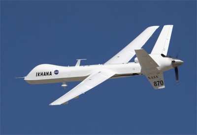
The Ikhana unmanned aircraft system, a Predator B modified for
civil science and research missions, was launched about 0845 PDT
from its base at NASA's Dryden Flight Research Center at Edwards
Air Force Base. It is expected to fly over the major blazes burning
in the Lake Arrowhead and Running Springs areas and possibly down
into San Diego County to image wildfires raging in that area. The
aircraft is controlled remotely by pilots in a ground control
station at NASA Dryden.
The Ikhana is carrying the Autonomous Modular Scanner, a
thermal-infrared imaging system developed at NASA's Ames Research
Center in Northern California. The system is capable of peering
through heavy smoke and darkness to see hot spots, flames and
temperature differences, processing the imagery on-board, and then
transmitting that information in near real time so it can aid fire
incident commanders in allocating their firefighting resources.
The images are transmitted through a communications satellite to
NASA Ames where the imagery is placed on an Ames Web site, combined
with Google Earth maps, and then transmitted to the interagency
fire center in Boise, ID where it is then made available to
incident commanders in the field.
As ANN reported, the Ikhana
system was validated recently during a series of wildfire imaging
demonstration missions conducted by NASA and the US Forest Service
in August and September.

Mission managers indicated a second imaging flight may occur on
Thursday, October 25, as well. Each flight is being coordinated
with the FAA to allow the remotely piloted aircraft to fly within
the national airspace while maintaining separation from other
aircraft.
More News
Aero Linx: Model Aeronautical Association of Australia MAAA clubs are about fun flying, camaraderie and community. For over 75 years, the MAAA has been Australia’s largest fl>[...]
Touchdown Zone Lighting Two rows of transverse light bars located symmetrically about the runway centerline normally at 100 foot intervals. The basic system extends 3,000 feet alon>[...]
“Discovery and innovation are central to our mission at Virgin Galactic. We’re excited to build on our successful record of facilitating scientific experiments in subor>[...]
How To Get A Story On Aero-TV News/Feature Programming How do I submit a story idea or lead to Aero-TV? If you would like to submit a story idea or lead, please contact Jim Campbel>[...]
Student Pilot Reported That During Rotation, “All Of A Sudden The Back Of The Plane Kicked To The Right..." Analysis: The student pilot reported that during rotation, “>[...]
 ANN's Daily Aero-Linx (05.02.24)

