WingX For Android Version 3 Available Now | Aero-News Network
Aero-News Network
RSS icon RSS feed
podcast icon MP3 podcast
Subscribe Aero-News e-mail Newsletter Subscribe

Airborne Unlimited -- Most Recent Daily Episodes

Episode Date

Airborne-Monday

Airborne-Tuesday

Airborne-Wednesday Airborne-Thursday

Airborne-Friday

Airborne On YouTube

Airborne-Unlimited-04.29.24

Airborne-Unlimited-04.23.24

Airborne-Unlimited-04.24.24 Airborne-FltTraining-04.25.24

Airborne-Unlimited-04.26.24

Tue, Jul 23, 2019

WingX For Android Version 3 Available Now

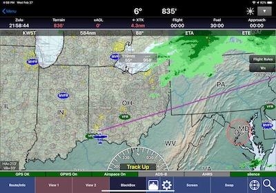
Visual Region Selection, Raster Overlays For Moving Maps Among The Upgrades

WingX has made Version 3 available for Android users. This is a free upgrade for all WingX users, and the company strongly recommends that users upgrade within the next two weeks to ensure uninterrupted service.

The primary features released with WingX for Android Version 3 include:

- Visual Region Selection – enables users to download specific chart types and regions on the Moving Map.
- Raster Overlays for the Moving Map – users can now overlay Terminal Area Charts (TACs), Helicopter Routes, US Gulf Coast VFR Charts, Grand Canyon VFR Charts and VFR Flyway Planning Charts on the Moving Map.
- Route Planning enhancements – increased overall ease of use and provides specific point and route summary information.
- Overhauled Bluetooth connection for ease of use and greater stability.
- External Hardware – new hardware specific information for connected ADS-B Receivers.
- Improved data cycle handling including dual cycle downloading.
- App and server enhancements for faster delivery of cycle data.
- Bug fixes and improvements to overall app stability.

WingX for Android Version 3 uses a completely new and improved Moving Map which requires new Moving Map files such as the VFR Sectionals, IFR Low/High Enroutes etc. Therefore, do not update WingX immediately prior to a flight (turn off Auto Updates on the Google Play Store temporarily if required). After installing WingX for Android Version 3, you will need to download the moving map files.

(Source: WingX news release. Image from file)

FMI: www.hiltonsoftware.com

Advertisement

More News

ANN's Daily Aero-Term (04.28.24): Airport Marking Aids

Airport Marking Aids Markings used on runway and taxiway surfaces to identify a specific runway, a runway threshold, a centerline, a hold line, etc. A runway should be marked in ac>[...]

Aero-News: Quote of the Day (04.28.24)

"It is extremely difficult, if not impossible, for manned aircraft to see a drone while conducting crop-enhancing and other aerial applications at low altitudes and high speeds. We>[...]

ANN's Daily Aero-Linx (04.28.24)

Aero Linx: The Skyhawk Association The Skyhawk Association is a non-profit organization founded by former Skyhawk Pilots which is open to anyone with an affinity for the A-4 Skyhaw>[...]

Aero-News: Quote of the Day (04.29.24)

“The T-54A benefits from an active Beechcraft King Air assembly line in Wichita, Kansas, where all required METS avionics and interior modifications are installed on the line>[...]

ANN's Daily Aero-Linx (04.29.24)

Aero Linx: Aerostar Owners Association The Association offers the Aerostar Owner a unique opportunity to tap an invaluable source of information concerning the care and feeding of >[...]

blog comments powered by Disqus


Advertisement

Advertisement

Podcasts

Advertisement

© 2007 - 2024 Web Development & Design by Pauli Systems, LC