GPS-Enabled Terrain-Aware Moving Map? There's An App For That | Aero-News Network
Aero-News Network
RSS icon RSS feed
podcast icon MP3 podcast
Subscribe Aero-News e-mail Newsletter Subscribe

Airborne Unlimited -- Most Recent Daily Episodes

Episode Date

Airborne-Monday

Airborne-Tuesday

Airborne-Wednesday Airborne-Thursday

Airborne-Friday

Airborne On YouTube

Airborne-Unlimited-04.29.24

Airborne-Unlimited-04.23.24

Airborne-Unlimited-04.24.24 Airborne-FltTraining-04.25.24

Airborne-Unlimited-04.26.24

Thu, Oct 01, 2009

GPS-Enabled Terrain-Aware Moving Map? There's An App For That

WingX Version 3.0 For iPhone Now Available

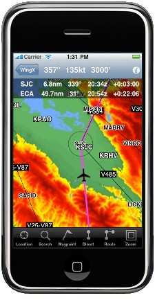
The glass cockpit has come to your pocket. Hilton Software LLC today announced “WingX for iPhone” Version 3.0 with GPS-Enabled Terrain-Aware Moving Map. WingX’s touchscreen integration reduces heads-down time while enabling smooth scrolling across the contiguous US, Mexico, Puerto Rico, and Bahamas.

WingX’s Moving Map has one-touch access to the A/FD, AOPA Directory, and NACO Approach Charts and Airport Diagrams. “We are very excited to add GPS-Enabled Moving Map to WingX for iPhone. WingX now enables pilots to carry just one device for their moving map, DUATS, weather text and images, A/FD, AOPA Directory, and all NACO approach charts and airport diagram in the US. Modifying the route, obtaining A/FD or AOPA Directory information or viewing an approach chart is initiated by one tap on the identifier. No knob twiddling or complicated instructions. WingX for iPhone Version 3.0 is also faster, uses less memory, adds TFR images, AF/D information for Puerto Rico and the Bahamas, and adds aircraft lookup. All this for under $100.” said Dr. Hilton Goldstein, company founder and CEO.

WingX for iPhone runs on iPhone, iPhone 3G, iPhone 3GS, and iPod Touch. WingX for iPhone Version 3.0 requires iPhone OS 3.0 (or later).

The iPhone application is available for download from the Apple App Store. BlackBerry and Windows Mobile versions can be found at the Hilton Software website.

FMI: www.hiltonsoftware.com

Advertisement

More News

Unfortunate... ANN/SportPlane Resource Guide Adds To Cautionary Advisories

The Industry Continues to be Rocked By Some Questionable Operations Recent investigations and a great deal of data has resulted in ANN’s SportPlane Resource Guide’s rep>[...]

ANN FAQ: Turn On Post Notifications

Make Sure You NEVER Miss A New Story From Aero-News Network Do you ever feel like you never see posts from a certain person or page on Facebook or Instagram? Here’s how you c>[...]

ANN's Daily Aero-Term (04.29.24): Visual Approach Slope Indicator (VASI)

Visual Approach Slope Indicator (VASI) An airport lighting facility providing vertical visual approach slope guidance to aircraft during approach to landing by radiating a directio>[...]

ANN's Daily Aero-Term (04.28.24): Airport Marking Aids

Airport Marking Aids Markings used on runway and taxiway surfaces to identify a specific runway, a runway threshold, a centerline, a hold line, etc. A runway should be marked in ac>[...]

ANN's Daily Aero-Linx (04.28.24)

Aero Linx: The Skyhawk Association The Skyhawk Association is a non-profit organization founded by former Skyhawk Pilots which is open to anyone with an affinity for the A-4 Skyhaw>[...]

blog comments powered by Disqus


Advertisement

Advertisement

Podcasts

Advertisement

© 2007 - 2024 Web Development & Design by Pauli Systems, LC