MD 500 Series Helicopters Will Soon Have Garmin G500H Option | Aero-News Network
Aero-News Network
RSS icon RSS feed
podcast icon MP3 podcast
Subscribe Aero-News e-mail Newsletter Subscribe

Airborne Unlimited -- Most Recent Daily Episodes

Episode Date

Airborne-Monday

Airborne-Tuesday

Airborne-Wednesday Airborne-Thursday

Airborne-Friday

Airborne On YouTube

Airborne-Unlimited-06.03.24

Airborne-NextGen-06.04.24

Airborne-Unlimited-06.05.24 Airborne-AffordableFlyers-06.06.24

Airborne-Unlimited-06.07.24

Thu, Mar 10, 2011

MD 500 Series Helicopters Will Soon Have Garmin G500H Option

System Designed For Part 27 VFR Helicopters

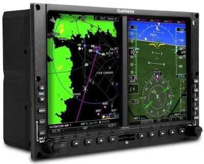
MD Helicopters has selected the G500H as an optional avionics package for the MD series helicopters Garmin announced Sunday. The G500H, is a certified, all-glass avionics system designed specifically for the VFR Part 27 helicopter market.

“The G500H is a perfect complement to the MD 500 series,” said Gary Kelley, Garmin’s vice president of marketing. “MD Helicopters has been a great partner and we’re excited to offer their customers an avionics flight deck that gives pilots the big picture on flight management, weather, terrain and traffic on a large PFD and MFD.”

The G500H has been optimized for rotorcraft and offers features like helicopter synthetic vision technology (HSVT), helicopter-specific databases with over 7,000 heliports and nearly 30,000 additional low-altitude obstacles, XM WX Satellite Weather with NEXRAD, and the ability to display video from a forward looking infrared (FLIR) camera or other video sources.

The bezel framing the G500H’s primary flight display (PFD) and multi-function display (MFD) (10”w x 6.7”h) allows for easy installation into the instrument panel. The G500H system includes a solid state Attitude and Heading Reference System (AHRS) for superior reliability and accuracy. Garmin’s AHRS features rapid alignment while moving, including in-flight dynamic restarts.

The G500H also supports Garmin’s helicopter-specific synthetic vision technology (HSVT). By adding the optional Garmin HSVT to the G500H, the PFD will display an “out-the-window” view of the surroundings, regardless of the weather conditions. HSVT seamlessly blends information about the rotorcraft’s position with topographic databases to create and display real-time 3D images. Land, water and sky are clearly differentiated with shading and textures that are similar to the topographical colors found on the MFD moving map. HSVT alerts pilots of potential ground hazards by displaying terrain and obstacles which pose a threat to the aircraft.

The G500H includes SafeTaxi, which features detailed diagrams of over 900 airports that assist pilots while maneuvering in the airport environment. A trial version of Garmin FliteCharts is included, which allows pilots to quickly find and view airport diagrams on the MFD. Pilots may also select the optional ChartView, an electronic version of Jeppesen’s extensive library of charts and airport diagrams.

MD Helicopters expects first G500H-equipped helicopter deliveries in third quarter of 2011.

www.garmin.com/helicopters

Advertisement

More News

Archer Gains Part 135 Air Carrier & Operator Certificate

With Certification In-Hand, the Story Continues Archer has been given some very good news as of late, now having been granted their operator certificate from the FAA. Even better f>[...]

Airborne 06.10.24: Gone West-Bill Anders, M700 FIKI, TFR Corrections

Also: Virgin Galactic, TBMOPA’s European Convention, B-29 Doc and B-25 Berlin Express, Fairchild XNQ-1 An astronaut who was part of what was then mankind's greatest adventure>[...]

Airborne 06.10.24: Gone West-Bill Anders, M700 FIKI, TFR Corrections

Also: Virgin Galactic, TBMOPA’s European Convention, B-29 Doc and B-25 Berlin Express, Fairchild XNQ-1 An astronaut who was part of what was then mankind's greatest adventure>[...]

Aero-News: Quote of the Day (06.11.24)

“For months, ALPA has been sounding the alarm on the ongoing efforts by some aircraft manufacturers to remove pilots from the flight deck and replace them with automation. To>[...]

FlightHorizon Chosen for Osage Nation's Skyway36 Droneport

Skyway Range Begins Planning for Traffic Early On Skyway 36 is shaping up to be a handy UAV development location, boasting a 3,000-foot runway a short hop from downtown Tulsa, Okla>[...]

blog comments powered by Disqus


Advertisement

Advertisement

Podcasts

Advertisement

© 2007 - 2024 Web Development & Design by Pauli Systems, LC