Drone Suspected In Wildfire In Arizona | Aero-News Network
Aero-News Network
RSS icon RSS feed
podcast icon MP3 podcast
Subscribe Aero-News e-mail Newsletter Subscribe

Airborne Unlimited -- Most Recent Daily Episodes

Episode Date

Airborne-Monday

Airborne-Tuesday

Airborne-Wednesday Airborne-Thursday

Airborne-Friday

Airborne On YouTube

Airborne-Unlimited-05.13.24

Airborne-NextGen-05.14.24

Airborne-Unlimited-05.15.24 Airborne-AffordableFlyers-05.16.24

Airborne-Unlimited-05.17.24

Mon, Mar 12, 2018

Drone Suspected In Wildfire In Arizona

About 30 Firefighters Contained The Blaze That Burned 335 Acres

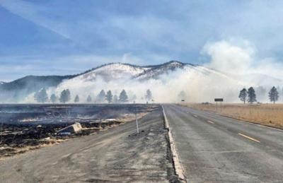
A drone is considered the culprit in a wildfire that burned some 335 acres near Kendrick Park in the Coconino National Forest near Flagstaff, AZ.

The U.S. Forest Service said in a news release that at approximately 12:35 p.m. local time last Tuesday, several firefighter crews responded to a smoke report from a drone in an area north of Flagstaff. The response included several Forest Service engines, patrols, and a water tender truck dispatched from the Summit fire department.

Overall, the fire burned 335-acres of forest land before the forward progress was stopped that afternoon.

Approximately 30 firefighters worked in the grasslands to stop the progress of this wildfire. The Chapel of the Holy Dove was in the area of the wildfire, but firefighting crews were able to protect the building by using fire to burn the fuels between the spreading wildfire and the Chapel. The backburning successfully kept damaging heat and flames away from the Chapel.

Several Forest Service engines, patrols and a water tender truck from Summit Fire responded to a smoke report from a drone on fire north of Flagstaff at approximately 12:35. The fire began near Forest Road 514 & FR 524 intersection by a drone which caught fire upon landing. The fire was reported as 50-acres in size upon the firefighter’s arrival.

Coconino National Forest spokesman George Jozens said authorities are still attempting to identify the type of drone, and who was operating the aircraft at the time on the incident.

(U.S. Forest Service image)

FMI: www.fs.usda.gov

Advertisement

More News

Classic Aero-TV: Remembering Bob Hoover

From 2023 (YouTube Version): Legacy of a Titan Robert (Bob) Anderson Hoover was a fighter pilot, test pilot, flight instructor, and air show superstar. More so, Bob Hoover was an i>[...]

ANN FAQ: Follow Us On Instagram!

Get The Latest in Aviation News NOW on Instagram Are you on Instagram yet? It's been around for a few years, quietly picking up traction mostly thanks to everybody's new obsession >[...]

ANN's Daily Aero-Linx (05.15.24)

Aero Linx: B-52H Stratofortress The B-52H Stratofortress is a long-range, heavy bomber that can perform a variety of missions. The bomber is capable of flying at high subsonic spee>[...]

ANN's Daily Aero-Term (05.15.24):Altimeter Setting

Altimeter Setting The barometric pressure reading used to adjust a pressure altimeter for variations in existing atmospheric pressure or to the standard altimeter setting (29.92).>[...]

Aero-News: Quote of the Day (05.16.24)

"Knowing that we play an active part in bettering people's lives is extremely rewarding. My team and I are very thankful for the opportunity to be here and to help in any way we ca>[...]

blog comments powered by Disqus


Advertisement

Advertisement

Podcasts

Advertisement

© 2007 - 2024 Web Development & Design by Pauli Systems, LC