As Provided By Seattle Avionics And ANN!
 We're gonna help you to
get to get to the fabled land of Oshkosh... with a little help from
our friends!
We're gonna help you to
get to get to the fabled land of Oshkosh... with a little help from
our friends!
In conjunction with our friends at Seattle Avionics, Aero-News
will be offering a Travel Update on our homepage, as well as for
readers of our daily Propwash newsletter, throughout AirVenture
2006.
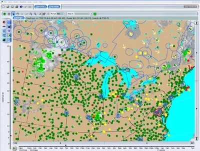
The graphic image, updated every morning, will show TFRs, radar,
cloud cover, winds aloft, and other data... all appearing on a
chart similar to what you'll find in Seattle Avionics' Voyager
FreeFlight software.

What's more, you can customize this image to display whatever
YOU want to show!
Traveling To Oshkosh?
This morning's weather report and airspace update are shown
updated at 7:00 AM EDT 07.18.06.
DUAT AREA SYNOPSIS, 7/18/2006, 8:27 CDT
 ...PA/OH AND MID MS
VALLEYS... COLD FRONT/OUTFLOW BOUNDARY EXTEND FROM WESTERN NY TO A
WEAK WAVE LOCATED IN NORTH CENTRAL IL...AND THEN SOUTHWESTWARD INTO
NORTHERN MO. ELEVATED CONVECTION HAD DEVELOPED OVER CENTRAL IL THIS
MORNING WITHIN INSTABILITY AXIS AND ZONE OF WEAK WARM
ADVECTION...BUT STORMS SHOULD WEAKEN THIS MORNING AS WARM ADVECTION
CEASES. MORE INTENSE CONVECTION IS EXPECTED TO DEVELOP THIS
AFTERNOON ALONG THE WEAK COLD FRONT/REMNANT OUTFLOW BOUNDARIES.
STRONG DAYTIME HEATING... STEEP MID LEVEL LAPSE RATES AND A MOIST
BOUNDARY LAYER WILL RESULT IN MLCAPES TO RANGE FROM 2000 J/KG OVER
PA/OH TO NEARLY 4000 J/KG ACROSS SOUTHERN IL/EAST CENTRAL MO. WARM
MID LEVEL TEMPERATURES SHOULD LIMIT WESTERN EXTENT OF CONVECTIVE
DEVELOPMENT TO EASTERN MO/IL...BUT MOST INTENSE CONVECTION SHOULD
BE LOCATED ON THE EASTERN EDGE OF THIS CAP. ONCE STORMS
DEVELOP...THE AMOUNT OF INSTABILITY AND 25-30 KNOTS DEEP LAYER
SHEAR WILL FAVOR MULTICELL STORM CLUSTERS WITH HAIL AND WIND
DAMAGE.
...PA/OH AND MID MS
VALLEYS... COLD FRONT/OUTFLOW BOUNDARY EXTEND FROM WESTERN NY TO A
WEAK WAVE LOCATED IN NORTH CENTRAL IL...AND THEN SOUTHWESTWARD INTO
NORTHERN MO. ELEVATED CONVECTION HAD DEVELOPED OVER CENTRAL IL THIS
MORNING WITHIN INSTABILITY AXIS AND ZONE OF WEAK WARM
ADVECTION...BUT STORMS SHOULD WEAKEN THIS MORNING AS WARM ADVECTION
CEASES. MORE INTENSE CONVECTION IS EXPECTED TO DEVELOP THIS
AFTERNOON ALONG THE WEAK COLD FRONT/REMNANT OUTFLOW BOUNDARIES.
STRONG DAYTIME HEATING... STEEP MID LEVEL LAPSE RATES AND A MOIST
BOUNDARY LAYER WILL RESULT IN MLCAPES TO RANGE FROM 2000 J/KG OVER
PA/OH TO NEARLY 4000 J/KG ACROSS SOUTHERN IL/EAST CENTRAL MO. WARM
MID LEVEL TEMPERATURES SHOULD LIMIT WESTERN EXTENT OF CONVECTIVE
DEVELOPMENT TO EASTERN MO/IL...BUT MOST INTENSE CONVECTION SHOULD
BE LOCATED ON THE EASTERN EDGE OF THIS CAP. ONCE STORMS
DEVELOP...THE AMOUNT OF INSTABILITY AND 25-30 KNOTS DEEP LAYER
SHEAR WILL FAVOR MULTICELL STORM CLUSTERS WITH HAIL AND WIND
DAMAGE.
...NORTHERN PLAINS... TIMING AND LOCATION OF SEVERE CONVECTION
IS QUESTIONABLE DUE TO SUBTLE DIFFERENCES IN THE CURRENT AND PAST
ETA/GFS MODEL RUNS. HOWEVER...MODELS GENERALLY SUPPORT A LOW LEVEL
JET/WARM ADVECTION DEVELOPING OVERNIGHT ACROSS THE EASTERN
DAKOTAS/WESTERN MN AS A SHORTWAVE TROUGH MOVES INTO THE NORTHERN
ROCKIES. THE BOUNDARY LAYER WILL BE STRONGLY CAPPED...BUT STEEP
LAPSE RATES ABOVE THE INVERSION WILL BE FAVORABLE FOR ELEVATED
CONVECTION TO DEVELOP AFTER 03-06Z. EFFECTIVE SHEAR WILL BE
INCREASING OVERNIGHT AND THE STEEP LAPSE RATES/ELEVATED CAPE MAY
SUPPORT STORMS WITH SEVERE HAIL.
Pretty cool, eh? But wait... it gets even better.
In addition to displaying this information on the Aero-News
website... Seattle Avionics is also offering a special, FREE version of Voyager FreeFlight for
ANN readers to download for their personal use.
For an up-to-the-minute look at the weather, airspace, and
airport data for your flight, be sure to download your 100% FREE
version of Voyager FreeFlight Flight Planner, courtesy of
Aero-News.
Use it for your flight to Oshkosh... and for your flights to
come!
FMI: Download Your ANN FreeFlight Flight Planner Here
 Classic Aero-TV: Remembering Bob Hoover

