New Unmanned Aircraft Systems Certificate Launches At UH Hilo | Aero-News Network
Aero-News Network
RSS icon RSS feed
podcast icon MP3 podcast
Subscribe Aero-News e-mail Newsletter Subscribe

Airborne Unlimited -- Most Recent Daily Episodes

Episode Date

Airborne-Monday

Airborne-Tuesday

Airborne-Wednesday Airborne-Thursday

Airborne-Friday

Airborne On YouTube

Airborne-Unlimited-05.20.24

Airborne-NextGen-05.14.24

Airborne-Unlimited-05.15.24 Airborne-AffordableFlyers-05.16.24

Airborne-Unlimited-05.17.24

Mon, Dec 04, 2017

New Unmanned Aircraft Systems Certificate Launches At UH Hilo

Launches Long-Planned Aeronautical Science Program At The University

Planning for future workforce needs, the University of Hawaii at Hilo launched four new courses this semester to establish a certificate in unmanned aircraft systems, a first step in the university’s long-planned aeronautical science program.

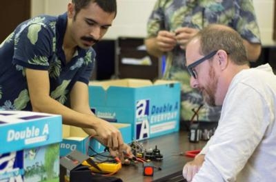
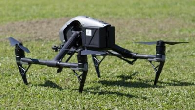
The certificate program focuses on training in the use of unmanned aerial vehicles and offers new courses this fall that include hands-on classroom and field work in an introductory course on unmanned aerial systems (UAS), robotics (building and flying UAS), simulated missions and flying techniques.

UH Hilo students who complete these four courses plus three upper-level geography classes in data interpretation, remote sensing and information systems receive a certificate in unmanned aircraft systems. According to the UH Hilo Course Catalog, “Graduates of the UAS certificate program will possess a skill set valuable in the unmanned aerial data collection field.”

“Unmanned aircraft are becoming more and more popular, with the potential being recognized by new industries every day,” said Arthur Cunningham, coordinator of the UH Hilo aeronautical science program.

In the introductory UAS course, students learn operational principles, laws and theory about UAS, and conclude with receiving an FAA remote pilot airman certificate (Part 107) with small UAS rating, which is a pilot license to operate unmanned aircraft commercially.

Licensed aircraft operators could potentially get jobs working with companies or government agencies for infrastructure inspections, real estate photography, agricultural mapping, natural disaster assessment, natural resource surveys, law enforcement or research in almost any field that uses sensors or cameras.

“UAS works well with my bioengineering background because these aircraft are able to collect data from a large plot of land using cameras, chemical sampling and water sampling,” said instructor Roberto Rodriguez. “This is especially useful for agriculture as a time and money-saving technology.”

(Images provided with UH news release)

FMI: www.hawaii.edu

Advertisement

More News

Airborne 05.20.24: Van's BK Exit, Bud Anderson, Air Race Classic

Also: ALPA Warns, Aviation Meteorology Reference, Jennifer Homendy Re-Ups, CAF Tampa Bay The court has approved Van's Aircraft's bankruptcy reorganization plans, settling a stressf>[...]

Airborne 05.20.24: Van's BK Exit, Bud Anderson, Air Race Classic

Also: ALPA Warns, Aviation Meteorology Reference, Jennifer Homendy Re-Ups, CAF Tampa Bay The court has approved Van's Aircraft's bankruptcy reorganization plans, settling a stressf>[...]

ANN's Daily Aero-Term (05.18.24): Flameout Pattern

Flameout Pattern An approach normally conducted by a single-engine military aircraft experiencing loss or anticipating loss of engine power or control. The standard overhead approa>[...]

ANN's Daily Aero-Linx (05.18.24)

Aero Linx: VC-25 - Air Force One The mission of the VC-25 aircraft — Air Force One — is to provide air transport for the president of the United States. The presidentia>[...]

ANN FAQ: How Do I Become A News Spy?

We're Everywhere... Thanks To You! Even with the vast resources and incredibly far-reaching scope of the Aero-News Network, every now and then a story that should be reported on sl>[...]

blog comments powered by Disqus


Advertisement

Advertisement

Podcasts

Advertisement

© 2007 - 2024 Web Development & Design by Pauli Systems, LC