Software Includes All-New Charting Engine, Geo-Referenced
Charts
On Friday, Seattle Avionics Software released its Voyager Flight
Software System version 4.0 -- merging a completely new, extremely
fast DirectX charting engine with version 3.6’s fuel stop
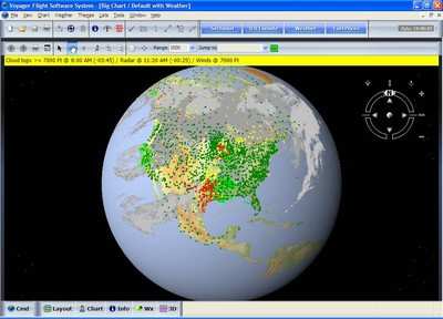
auto-routing, Google Earth integration and over 200 other new
features.
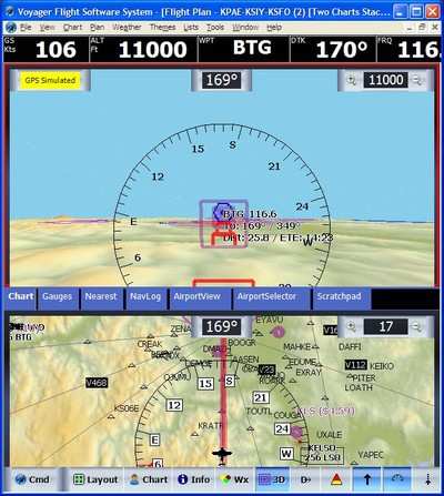
Voyager 4.0 features a completely new charting engine based on
DirectX technology -- the same technology used in Google Earth and
Microsoft Flight Simulator. Voyager’s all-new charting engine
is extremely fast, redrawing images nearly instantaneously and
capable of updating the screen more than 50 times a second,
depending on hardware. This allows completely smooth zooms and
pans—the first general aviation software offering this
state-of-the-art technology.
 In addition to
replacement of the charting engine, Voyager 4.0 incorporates over
200 product enhancements and improvements. Key among them is the
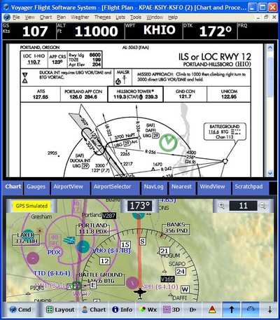
ability to display any combination of computer-generated (often
called digital) charts with scanned, geo-referenced Sectional and
IFR charts, which look identical to paper charts. This enables
pilots to both plan and fly using geo-referenced Sectionals or IFR
enroute charts with overlaid weather, TFRs, and aircraft
position.
In addition to
replacement of the charting engine, Voyager 4.0 incorporates over
200 product enhancements and improvements. Key among them is the
ability to display any combination of computer-generated (often
called digital) charts with scanned, geo-referenced Sectional and
IFR charts, which look identical to paper charts. This enables
pilots to both plan and fly using geo-referenced Sectionals or IFR
enroute charts with overlaid weather, TFRs, and aircraft
position.
Company representatives state Voyager 4.0 seamlessly merges all
Sectionals and IFR charts so pilots need not select particular
charts to display; they simply pick the type of chart to display
and Voyager does the rest. Other major enhancements to Voyager
include three-dimensional highway-in-the-sky features, night
vision-friendly color scheme, and much, much more.
"This version of Voyager has been in the works for nearly two
years and we’re delighted to be releasing it today," says
John Rutter, President of Seattle Avionics Software. "Over the
years, pilots have said they loved Voyager’s features but
wanted it to be faster. We listened and rewrote the charting engine
from the ground up, the difference being like night and day.
Furthermore, rather than write a fast but strictly 2D charting
engine, we opted to spend the time and resources to use the very
latest high-speed 3D graphics technology to lay the foundation for
future versions of Voyager."
"We had two different development teams working on Voyager 4.0",
adds Steve Podradchik, CEO, who led the development effort. "One
team wrote a new charting engine from scratch, using the same very
high-speed Microsoft DirectX technology that drives video games,
Google Earth, Xbox, etc. The other team looked at all the feature
requests we’ve received over the years and put in about 200
major improvements like adding scanned Sectionals and IFR Charts,
doing a complete overhaul of GlassView (the moving map module), 3D
Highway in the Sky features, more modern and night-friendly color
scheme, faster startup, and much, much more."
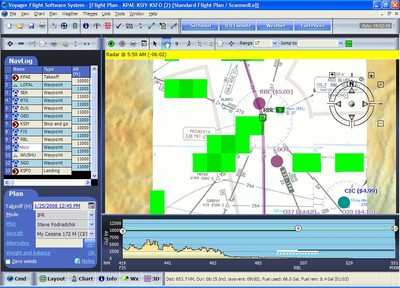
New features include:
- Extremely fast DirectX-based charting engine
- Scanned Sectionals and IFR Low/IFR High Charts merged with
digital TFR and Weather data. In addition, shows aircraft position
in GlassView, Voyager’s moving-map module.
- Personal Layouts so you can customize everything on the screen
with a single click
- Web Synch that performs "one-click" data synchronization among
multiple computers
- Completely updated GlassView module
- More modern look and feel, including 3D as well as 2D views and
enhanced chart colors
Pilots are invited to a personal demonstration of new Voyager
4.0 at the Northwest Aviation Conference & Trade Show, which
kicks off this weekend in Puyallup, WA. In addition, Seattle
Avionics Software offers on its Web site self-running product
demonstrations, free live on-line ‘Webinars’, and a
free version of Voyager called FreeFlight.
 ANN's Daily Aero-Term (04.30.24): Runway Centerline Lighting

