SmarTopo Harvest Develops A 'Safe Zone' For UAVS | Aero-News Network
Aero-News Network
RSS icon RSS feed
podcast icon MP3 podcast
Subscribe Aero-News e-mail Newsletter Subscribe

Airborne Unlimited -- Most Recent Daily Episodes

Episode Date

Airborne-Monday

Airborne-Tuesday

Airborne-Wednesday Airborne-Thursday

Airborne-Friday

Airborne On YouTube

Airborne-Unlimited-04.29.24

Airborne-NextGen-04.30.24

Airborne-Unlimited-05.01.24 Airborne-AffordableFlyers--05.02.24

Airborne-Unlimited-05.03.24

Tue, Mar 31, 2015

SmarTopo Harvest Develops A 'Safe Zone' For UAVS

New Obstacle Detection Technology For The SmarTopo Obstacle Management System

Rapid Imaging Software, Inc. introduced SmarTopo Harvest on Monday. This new technology is integrated into the SmarTopo Obstacle Management System. SmarTopo delivers obstacle survey and detection technology plus powerful data management tools for a complete obstacle management system. SmarTopo is certified by the FAA to a level 1B.

Mike Abernathy, Director of Development notes, “SmarTopo Harvest is the key for small commercial drones to operate safely in urban areas. This technology allows companies to create and maintain an obstacle database for their drone operations."

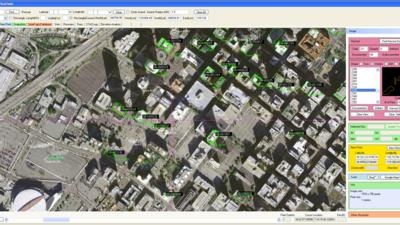
SmarTopo Harvest is the latest obstacle detection technology from Rapid Imaging Software. The software provides a fast and efficient method to detect undocumented obstacles and add new obstacles to a database.

  • Searches for obstacles – the height for the search is set by the analyst
  • Detected objects or structures may be compared to the FAA obstacle database
  • Estimates height of the objects or structures
  • Creates new obstacle for a proprietary database

The issue of undocumented obstacles is extensive. A recent study conducted using SmarTopo Harvest indicates there are a substantial number of undocumented obstacles in the national airspace. An analyst using SmarTopo Harvest identified 52 undocumented obstacles of 200 feet or more in a study area of six square miles around the Los Angeles International Airport.

(Image provided by Rapid Imaging Software)

FMI: www.rapidimaging.net/obstaclemanagement/

Advertisement

More News

ANN's Daily Aero-Term (05.01.24): Say Altitude

Say Altitude Used by ATC to ascertain an aircraft's specific altitude/flight level. When the aircraft is climbing or descending, the pilot should state the indicated altitude round>[...]

ANN's Daily Aero-Linx (05.01.24)

Aero Linx: European Air Law Association (EALA) EALA was established in 1988 with the aim to promote the study of European air law and to provide an open forum for those with an int>[...]

Classic Aero-TV: Korean War Hero Twice Reborn

From 2023 (YouTube Version): The Life, Death, Life, Death, and Life of a Glorious Warbird In 1981, business-owner Jim Tobul and his father purchased a Chance-Vought F4U Corsair. Mo>[...]

Airborne 04.29.24: EAA B-25 Rides, Textron 2024, G700 Deliveries

Also: USCG Retires MH-65 Dolphins, Irish Aviation Authority, NATCA Warns FAA, Diamond DA42 AD This summer, history enthusiasts will have a unique opportunity to experience World Wa>[...]

Airborne Affordable Flyers 05.02.24: Bobby Bailey, SPRG Report Cards, Skydive!

Also: WACO Kitchen Bails, French SportPlane Mfr to FL, Dynon-Advance Flight Systems, Innovation Preview Bobby Bailey, a bit of a fixture in sport aviation circles for his work with>[...]

blog comments powered by Disqus


Advertisement

Advertisement

Podcasts

Advertisement

© 2007 - 2024 Web Development & Design by Pauli Systems, LC