Voyager FPS and ANN Bring YOU The Weather In Oshkosh For Friday 07.21.06 | Aero-News Network
Aero-News Network
RSS icon RSS feed
podcast icon MP3 podcast
Subscribe Aero-News e-mail Newsletter Subscribe

Airborne Unlimited -- Most Recent Daily Episodes

Episode Date

Airborne-Monday

Airborne-Tuesday

Airborne-Wednesday Airborne-Thursday

Airborne-Friday

Airborne On YouTube

Airborne-Unlimited-05.20.24

Airborne-Unlimited-05.28.24

Airborne-FlightTraining-05.29.24 Airborne-Unlimited-05.30.24

Airborne-Unlimited-05.24.24

Fri, Jul 21, 2006

Voyager FPS and ANN Bring YOU The Weather In Oshkosh For Friday 07.21.06

As Provided By Seattle Avionics And ANN!

We're gonna help you get to the fabled land of Oshkosh... with a little help from our friends!

In conjunction with our friends at Seattle Avionics, Aero-News will be offering a Travel Update on our homepage, as well as for readers of our daily Propwash newsletter, throughout AirVenture 2006.

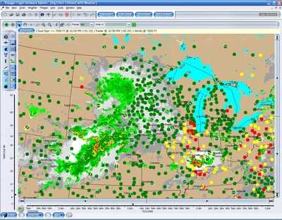
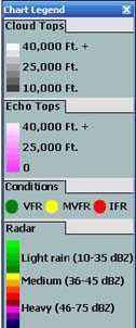
The graphic image, updated every morning, will show TFRs, radar, cloud cover, winds aloft, and other data... all appearing on a chart similar to what you'll find in Seattle Avionics' Voyager FreeFlight software.

What's more, you can customize this image to display whatever YOU want to show!

Traveling To Oshkosh?

This morning's weather report and airspace update are shown updated at 2:00 AM EDT 07.21.06.

DUAT SYNOPSIS

SYNOPSIS AND VFR CLOUDS/WEATHER SYNOPSIS VALID UNTIL 212000 CLOUDS/WEATHER VALID UNTIL 211400...OUTLOOK VALID 211400-212000 ND SD NE KS MN IA MO WI LM LS MI LH IL IN KY

SYNOPSIS...COLD FRONT ECK-ORD-STL-OSW-LAA FORECAST 20Z HNN-PXV-RZC SOUTHWESTWARD. HIGH PRESSURE RDG BUILDING N OF COLD FRONT THROUGH PERIOD.

WI N HALF...BROKEN CIRRUS. 09Z OCCASIONAL VIS 3-5SM MIST. OUTLOOK...VFR. S HALF...SCATTERED 3/8-4/8 COVERAGE AT 6000 FT BROKEN CIRRUS. 09Z ABOVE GROUND LEVEL SCT015-025. OCCASIONAL VIS 3-5SM MIST. OUTLOOK...VFR.

LS UPPER MI SKY CLEAR TO SCATTERED CIRRUS. OUTLOOK...VFR.

LM LOWER MI LH N HALF...CEILING BROKEN 5/8-7/8 COVERAGE-SCATTERED 3/8-4/8 COVERAGE AT 3000 FT TOPS 150. UNTIL 06Z WIDELY SCATTERED LIGHT THUNDERSTORM RAIN. CUMULONIMBUS TOP FL400. OUTLOOK...VFR. S HALF...CEILING BROKEN 5/8-7/8 COVERAGE AT 6000 FT OVERCAST AT 8000 FT LAYERED FL250. UNTIL 04Z ISOL LIGHT THUNDERSTORM RAIN. CUMULONIMBUS TOP FL400. BECMG 0608 SCATTERED CIRRUS. OCCASIONAL VIS 3-5SM MIST. OUTLOOK...VFR.

Pretty cool, eh? But wait... it gets even better. In addition to displaying this information on the Aero-News website... Seattle Avionics is also offering a special, FREE version of Voyager FreeFlight for ANN readers to download for their personal use.

For an up-to-the-minute look at the weather, airspace, and airport data for your flight, be sure to download your 100% FREE version of Voyager FreeFlight Flight Planner, courtesy of Aero-News. Use it for your flight to Oshkosh... and for your flights to come!

FMI: Download Your ANN FreeFlight Flight Planner Here

Advertisement

More News

ANN FAQ: Contributing To Aero-TV

How To Get A Story On Aero-TV News/Feature Programming How do I submit a story idea or lead to Aero-TV? If you would like to submit a story idea or lead, please contact Jim Campbel>[...]

ANN's Daily Aero-Linx (05.29.24)

Aero Linx: International Association of Professional Gyroplane Training (IAPGT) We are an Association of people who fly, build or regulate Gyroplanes, who have a dream of a single >[...]

ANN's Daily Aero-Term (05.29.24): NORDO (No Radio)

NORDO (No Radio) Aircraft that cannot or do not communicate by radio when radio communication is required are referred to as “NORDO.”>[...]

ANN's Daily Aero-Term (05.30.24): Beyond Visual Line Of Sight (BVLOS)

Beyond Visual Line Of Sight (BVLOS) The operation of a UAS beyond the visual capability of the flight crew members (i.e., remote pilot in command [RPIC], the person manipulating th>[...]

ANN's Daily Aero-Linx (05.30.24)

Aero Linx: Malibu M-Class Owners and Pilots Association (MMOPA) The Piper M-Class Owners & Pilots Association (PMOPA) is a not-for-profit organization dedicated to the interest>[...]

blog comments powered by Disqus


Advertisement

Advertisement

Podcasts

Advertisement

© 2007 - 2024 Web Development & Design by Pauli Systems, LC