Delair Unveils A New Large-Area Mapping Drone | Aero-News Network
Aero-News Network
RSS icon RSS feed
podcast icon MP3 podcast
Subscribe Aero-News e-mail Newsletter Subscribe

Airborne Unlimited -- Most Recent Daily Episodes

Episode Date

Airborne-Monday

Airborne-Tuesday

Airborne-Wednesday Airborne-Thursday

Airborne-Friday

Airborne On YouTube

Airborne-Unlimited-05.13.24

Airborne-NextGen-05.14.24

Airborne-Unlimited-05.15.24 Airborne-AffordableFlyers-05.16.24

Airborne-Unlimited-05.17.24

Sat, Sep 30, 2017

Delair Unveils A New Large-Area Mapping Drone

Aircraft Features 3G/4G Communications And Onboard Processing Capabilities

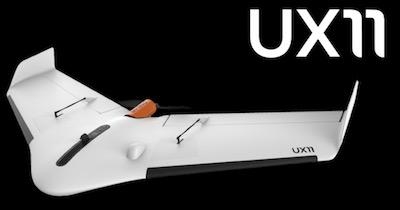
Drone manufacturer Delair has introduced its next-generation professional unmanned aerial vehicle (UAV) for survey-grade photogrammetric mapping, the UX11, at INTERGEO 2017 in Berlin, Germany. This small fixed-wing UAV combines a powerful integrated onboard system, industry-grade sensors, limitless communication range and PPK centimeter-level positioning.

The UX11 carries enough onboard computing power to access and process the pictures, then send them to the operator in real-time. It will run automated quality checks on the images (such as blur detection or overlap checks) to help ensure the operator is acquiring quality data.

The UX11's redundant communications system includes a proprietary line of sight radio and 3G/4G connectivity between the ground control station and the UAV using a worldwide machine-to-machine pre-paid plan. Building on Delair's experience with beyond visual line of sight (BVLOS) operations since 2012, the UX11 is ready for BVLOS flights with unlimited range and adds a new level of safety with this groundbreaking communication link.

"The UX11 by Delair is the ultimate solution for geospatial professionals that demand large-area mapping with centimeter-level precision," said Michael de Lagarde, Delair's CEO. "The UX11 will be capable of using its camera for enhanced safety procedures and even running early-stage pre-processing calculations onboard in real time using photogrammetry and deep learning algorithms. This expedites subsequent steps in the data processing chain for an optimized workflow. With the UX11, everything is done for a clear and efficient user experience."

(Source: Deair news release. Image provided)

FMI: www.delair.aero

Advertisement

More News

Classic Aero-TV: Remembering Bob Hoover

From 2023 (YouTube Version): Legacy of a Titan Robert (Bob) Anderson Hoover was a fighter pilot, test pilot, flight instructor, and air show superstar. More so, Bob Hoover was an i>[...]

ANN FAQ: Follow Us On Instagram!

Get The Latest in Aviation News NOW on Instagram Are you on Instagram yet? It's been around for a few years, quietly picking up traction mostly thanks to everybody's new obsession >[...]

ANN's Daily Aero-Linx (05.15.24)

Aero Linx: B-52H Stratofortress The B-52H Stratofortress is a long-range, heavy bomber that can perform a variety of missions. The bomber is capable of flying at high subsonic spee>[...]

ANN's Daily Aero-Term (05.15.24):Altimeter Setting

Altimeter Setting The barometric pressure reading used to adjust a pressure altimeter for variations in existing atmospheric pressure or to the standard altimeter setting (29.92).>[...]

Aero-News: Quote of the Day (05.16.24)

"Knowing that we play an active part in bettering people's lives is extremely rewarding. My team and I are very thankful for the opportunity to be here and to help in any way we ca>[...]

blog comments powered by Disqus


Advertisement

Advertisement

Podcasts

Advertisement

© 2007 - 2024 Web Development & Design by Pauli Systems, LC