Charles River Analytics Develops Satellite Image Processing System For NASA | Aero-News Network
Aero-News Network
RSS icon RSS feed
podcast icon MP3 podcast
Subscribe Aero-News e-mail Newsletter Subscribe

Airborne Unlimited -- Most Recent Daily Episodes

Episode Date

Airborne-Monday

Airborne-Tuesday

Airborne-Wednesday Airborne-Thursday

Airborne-Friday

Airborne On YouTube

Airborne-Unlimited-06.03.24

Airborne-NextGen-06.04.24

Airborne-Unlimited-06.05.24 Airborne-AffordableFlyers-06.06.24

Airborne-Unlimited-06.07.24

Sun, Jan 12, 2014

Charles River Analytics Develops Satellite Image Processing System For NASA

DIPSARS Detects Large-Scale Environmental Events From Satellite Imagery

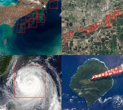
Charles River Analytics has been awarded a contract to develop a system for NASA. The system known as DIPSARS, for the Discovery of Interesting Patterns and Semantic Analysis in Remote Space, detects large-scale environmental events from satellite imagery. These events include volcanic eruptions, storms, and algae blooms, captured in images such as those produced from the NASA Earth Observing-1 (EO-1) satellite, as illustrated here.

The volume of satellite and rover data collected by NASA has grown dramatically as new missions are launched with ever-increasing sensor payloads. The data to be processed by DIPSARS includes different scenes and objects that research scientists and mission controllers use to determine which areas should be explored further. The sheer volume of data, combined with bandwidth limitations, is driving a need to process and analyze which data is relevant, important, and interesting enough to prompt follow-on action, all in real-time onboard the spacecraft.

DIPSARS leverages Charles River’s Object Detection Framework (ODF), a capability developed over several years to address the computer vision market. The ODF is a generalized detection framework that can detect objects and phenomena in image data in real-time. “DIPSARS will expand the use of our state-of-the art detection framework to new platforms and data,” said Tom Moore, the lead software engineer for the project.

“We’re excited by the potential of this project to enable autonomous decisions by satellites, resulting in fewer missed opportunities to observe significant events,” said Daniel Stouch, Principal Investigator on the project. “It will also free up valuable communications bandwidth that can then be used to transmit data of interest back to NASA and the research community in a more timely fashion.”

(Images provided by Charles River Analytics)

FMI: www.cra.com

Advertisement

More News

Archer Gains Part 135 Air Carrier & Operator Certificate

With Certification In-Hand, the Story Continues Archer has been given some very good news as of late, now having been granted their operator certificate from the FAA. Even better f>[...]

Airborne 06.10.24: Gone West-Bill Anders, M700 FIKI, TFR Corrections

Also: Virgin Galactic, TBMOPA’s European Convention, B-29 Doc and B-25 Berlin Express, Fairchild XNQ-1 An astronaut who was part of what was then mankind's greatest adventure>[...]

Airborne 06.10.24: Gone West-Bill Anders, M700 FIKI, TFR Corrections

Also: Virgin Galactic, TBMOPA’s European Convention, B-29 Doc and B-25 Berlin Express, Fairchild XNQ-1 An astronaut who was part of what was then mankind's greatest adventure>[...]

Aero-News: Quote of the Day (06.11.24)

“For months, ALPA has been sounding the alarm on the ongoing efforts by some aircraft manufacturers to remove pilots from the flight deck and replace them with automation. To>[...]

FlightHorizon Chosen for Osage Nation's Skyway36 Droneport

Skyway Range Begins Planning for Traffic Early On Skyway 36 is shaping up to be a handy UAV development location, boasting a 3,000-foot runway a short hop from downtown Tulsa, Okla>[...]

blog comments powered by Disqus


Advertisement

Advertisement

Podcasts

Advertisement

© 2007 - 2024 Web Development & Design by Pauli Systems, LC