Units Will Search For Minerals, Water Using 3-D Laser
Scanners
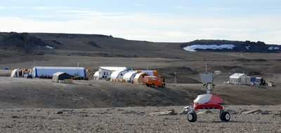
Two National Aeronautics and Space Administration robots are
surveying a rocky, isolated polar desert within a crater in the
Arctic Circle. The study will help scientists learn how robots
could evaluate potential outposts on the moon or Mars.
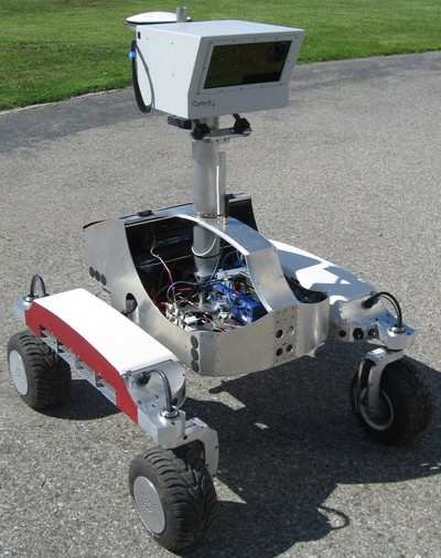
The robots, K10 Black and K10 Red, carry 3-D laser scanners and
ground-penetrating radar. The team arrived at Haughton Crater at
Devon Island, Canada, on July 12 and will operate the machines
until July 31, according to the space agency.
Scientists chose the polar region because of the extreme
environmental conditions, lack of infrastructure and resources, and
geologic features. Haughton Crater is also geographically similar
to Shackleton Crater at the South Pole of the moon. Both are impact
craters that measure roughly 12.4 miles in diameter.
"We are learning about the awesome potential of human and robot
teams," said S. Pete Worden, director of NASA's Ames Research
Center in Moffett Field, Calif., where the group conducting the
survey is based. "Studying how humans and robots can maximize
scientific returns in sites such as Devon Island will prepare us to
walk on the moon and Mars."
 NASA
is planning to send astronauts back to the moon by 2020. Prior to
establishing a lunar outpost, the agency must conduct detailed
surveys at a variety of locations to produce maps, look for
minerals and water, and learn other details. NASA plans to
accomplish its surveys with an automated orbiting spacecraft, not a
robotic lander, but the agency still has an interest in advancing
the laser scanning technology.
NASA
is planning to send astronauts back to the moon by 2020. Prior to
establishing a lunar outpost, the agency must conduct detailed
surveys at a variety of locations to produce maps, look for
minerals and water, and learn other details. NASA plans to
accomplish its surveys with an automated orbiting spacecraft, not a
robotic lander, but the agency still has an interest in advancing
the laser scanning technology.
Most of the lunar sites are on harsh terrain and in permanently
shadowed areas. It is not unusual for site surveys to require
thousands of measurements and hundreds of hours to complete. A
robot can reduce mission cost and improve mission effectiveness by
allowing ground control to conduct surveying tasks.
"A typical scenario involves multiple rovers autonomously
surveying a region while humans supervise and assess data from a
remote location," said Terry Fong, director of the Intelligent
Robots Group at Ames.
The robots are using different techniques than the goal-directed
traverses and isolated sampling tasks that Mars scientific rovers
have used to explore the Red Planet. K10 Black and K10 Red are
using a mix of information previously obtained by aerial and
satellite imaging and data that the robot survey team is
gathering.
The 3-D laser scanner can map topographic features as far as
3,280 feet away. The ground-penetrating radar, which NASA's Jet
Propulsion Laboratory in Pasadena, CA.
"The robots are covering the area in lawnmower-like paths at
human walking speeds to systematically map above and below ground,"
said Fong.
The practice survey in Haughton Crater is taking place at an
area called Drill Hill. The robots are covering approximately 120
acres of terrain. Researchers are commanding the robots remotely
from the Haughton-Mars base camp more than two miles away from
Drill Hill.
The robots navigate using the Global Positioning System, stereo
cameras, laser scanners and sun trackers. Each of the
four-wheel-drive machines weighs 165 pounds and can carry a payload
up to 110 pounds.
A key objective of the Drill Hill survey is to test the
instrument sand software on the robots as well as the equipment and
software humans will use at lunar outposts and ground control to
supervise the robots. Engineers at NASA's Johnson Space Center in
Houston will assess advanced robot driving techniques using a
multi-screen cockpit. Ames will test software that makes
high-resolution maps for interactive display in 3-D.
 Unfortunate... ANN/SportPlane Resource Guide Adds To Cautionary Advisories

