Mon, Dec 09, 2013
Vermont State Police Created Special Training Scenario At Army Facility
As a result of ongoing conversations with law enforcement personnel, the Unmanned Systems & Security Product (USPD) Division of ARA recently had the opportunity to demonstrate the Nighthawk IV Micro Unmanned Air System (UAS) to the Vermont State Police search-and-rescue and accident reconstruction teams and an Army Civil Support Team (CST). Although members of the public have cited privacy concerns regarding micro-UAS technology, use in national airspace, search-and-rescue and accident reconstruction missions could provide benefits far outweighing these concerns, the company says.
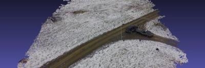
The Vermont State Police specifically created a training scenario using military airspace at an Army training facility to take an initial look at Nighthawk performing these two missions. The demonstration started by having a State Police vehicle drive away to a hidden location from the Nighthawk launch and recovery area. Once at the hidden location, the officers used a cell phone to call 911 to simulate a lost person calling for help. The dispatcher then contacted the State Police officers at the launch and recovery site, providing the latitude and longitude coordinates of the hidden State Police vehicle. This location was manually entered into the Nighthawk autopilot. About four minutes later, the Nighthawk was circling this vehicle using its EO/IR cameras to identify the target. The demonstration continued with additional search-and-rescue and accident reconstruction flights using customized ARA software to quickly post-process the digitized imagery into usable information.
The Nighthawk demonstration proved that the ability to fly to last-known GPS coordinates in minutes to begin a search can be a lifesaver, as elapsed time is a critical component to safe recovery. Using Nighthawk for search-and-rescue operations would save lives and bolster the emotional well-being of relatives and search teams looking for missing persons. Nighthawk’s accident reconstruction capability would give juries a much better understanding of the accident scene by creating a bird’s-eye view of the entire accident scene.
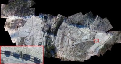
State Police and Army CST observers were impressed with the Nighthawk’s small size and ease of launch and recovery, and the hands-free autopilot operations. On-board high-definition imagery created a detailed photo, with geo-rectified precise locations, allowing users to conduct an aerial search with greater precision and faster response time than is currently possible.
Captain Robert Evans with the Vermont State Police said, "I was very pleased with the way things worked out today. I have spoken with my personnel and members of the civil support team and they were pleased as well. We are ready to support another training and evaluation day once you have some time to reflect on today's missions."
(Images provided by ARA)
More News
The Industry Continues to be Rocked By Some Questionable Operations Recent investigations and a great deal of data has resulted in ANN’s SportPlane Resource Guide’s rep>[...]
Make Sure You NEVER Miss A New Story From Aero-News Network Do you ever feel like you never see posts from a certain person or page on Facebook or Instagram? Here’s how you c>[...]
Visual Approach Slope Indicator (VASI) An airport lighting facility providing vertical visual approach slope guidance to aircraft during approach to landing by radiating a directio>[...]
Airport Marking Aids Markings used on runway and taxiway surfaces to identify a specific runway, a runway threshold, a centerline, a hold line, etc. A runway should be marked in ac>[...]
Aero Linx: The Skyhawk Association The Skyhawk Association is a non-profit organization founded by former Skyhawk Pilots which is open to anyone with an affinity for the A-4 Skyhaw>[...]
 Unfortunate... ANN/SportPlane Resource Guide Adds To Cautionary Advisories

