Microsoft AirSim Platform: A Flight Training Simulator—For Drones | Aero-News Network
Aero-News Network
RSS icon RSS feed
podcast icon MP3 podcast
Subscribe Aero-News e-mail Newsletter Subscribe

Airborne Unlimited -- Most Recent Daily Episodes

Episode Date

Airborne-Monday

Airborne-Tuesday

Airborne-Wednesday Airborne-Thursday

Airborne-Friday

Airborne On YouTube

Airborne-Unlimited-05.13.24

Airborne-NextGen-05.07.24

Airborne-Unlimited-05.08.24 Airborne-FlightTraining-05.09.24

Airborne-Unlimited-05.10.24

Tue, Jul 26, 2022

Microsoft AirSim Platform: A Flight Training Simulator—For Drones

Play it Again, HAL

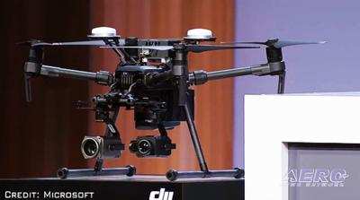
Seattle tech titan, Microsoft, has launched a software platform that enables drone operators to train the artificial intelligence systems of their autonomous air-vehicles. Subject platform—dubbed AirSim—constitutes, in effect, a simulator for drones. AirSim facilitates training scenarios too risky to be attempted in actuality, such as operations near power-lines, nuclear reactors, or Gary, Indiana.

Microsoft claims the AirSim platform allows users to contemporaneously simulate multiple flight-environments and the variables thereof. For example, operators may virtually assess how far a particular Unmanned Air Vehicle (UAV) is capable of flying in rain, or how strong winds might affect its battery-life.

In a statement announcing the product’s launch, Microsoft corporate vice president Gurdeep Pall asserted AirSim demonstrated “the power of the industrial metaverse—the virtual worlds where businesses will build, test, and hone solutions, then bring them into the real world.”

Microsoft expects the AirSim technology will prove particularly relevant within the emergent autonomous air-taxi and drone delivery sectors.

Early access to the AirSim platform—which runs on Microsoft’s Azure cloud computing service—was granted to Airtonomy, a U.S. provider of robotics software and UAV services. Airtonomy’s drones inspect infrastructure the likes of wind-turbines and power-lines across the oil and gas, power-generation, power-distribution, telecommunications, and insurance industries.

Airtonomy CEO josh Riedy thusly described the conventional means by which wind-turbine blades are inspected: “A crew of three individuals rappelled down those blades; the towers are at a height of 80m (262 ft), so not only was it nearly a day-long job for three individuals, [sic] safety is certainly a consideration.”

Airtonomy drones fly autonomously and can be controlled by a single operator safely boots-down on the Earth. “"They simply need to know how to put batteries in a drone, and push a button," Mister Riedy remarked.

The inspection profiles flown by Airtonomy’s drones are developed in the virtual AirSim environment, which affords Airtonomy UAV programmers and operators opportunity to err without destroying expensive drones and blacking-out entire towns. The AirSim platform also permits developers to explore hypothetical scenarios too impractical or flat-out dangerous to undertake in the real world, e.g., bird-strikes, partial power-loss, degradation of UAV sensor acuity, loss of positioning data, etc.

In addition to libraries of digital environments, AirSim operators will have access to AI building-blocks, comprising data gleaned during past UAV training simulations.

Ashish Kapoor, creator of the original open-source AirSim software expressed hope that data gathered on the new platform would help put "many more vehicles in the sky, helping to monitor farms, inspect critical infrastructure, and transport goods and people to the remotest of places.” Such as Gary, Indiana.

FMI: www.microsoft.com

Advertisement

More News

Airborne 05.10.24: Icon Auction, Drunk MedEvac Pilot, Bell ALFA

Also: SkyReach Parts Support, Piper Service Ctr, Airliner Near-Miss, Airshow London The Judge overseeing Icon's convoluted Chapter 11 process has approved $9 million in Chapter 11 >[...]

ANN's Daily Aero-Term (05.13.24): ILS PRM Approach

ILS PRM Approach An instrument landing system (ILS) approach conducted to parallel runways whose extended centerlines are separated by less than 4,300 feet and at least 3,000 feet >[...]

ANN's Daily Aero-Linx (05.13.24)

Aero Linx: FlyPups FlyPups transports dogs from desperate situations to fosters, no-kill shelters, and fur-ever homes. We deliver trained dogs to veterans for service and companion>[...]

Airborne-NextGen 05.07.24: AI-Piloted F-16, AgEagle, 1st 2 WorldView Sats

Also: Skydio Chief, Uncle Sam Sues, Dash 7 magniX, OR UAS Accelerator US Secretary of the Air Force Frank Kendall was given a turn around the patch in the 'X-62A Variable In-flight>[...]

Airborne 05.08.24: Denali Update, Dad-Daughter Gyro, Lake SAIB

Also: NBAA on FAA Reauth, DJI AG Drones, HI Insurance Bill Defeated, SPSA Airtankers The Beechcraft Denali continues moving forward towards certification, having received its FAA T>[...]

blog comments powered by Disqus


Advertisement

Advertisement

Podcasts

Advertisement

© 2007 - 2024 Web Development & Design by Pauli Systems, LC