Signs Of Ancient Mars Lakes And Quakes Seen In New Map | Aero-News Network
Aero-News Network
RSS icon RSS feed
podcast icon MP3 podcast
Subscribe Aero-News e-mail Newsletter Subscribe

Airborne Unlimited -- Most Recent Daily Episodes

Episode Date

Airborne-Monday

Airborne-Tuesday

Airborne-Wednesday Airborne-Thursday

Airborne-Friday

Airborne On YouTube

Airborne-Unlimited-04.22.24

Airborne-Unlimited-04.16.24

Airborne-FlightTraining-04.17.24 Airborne-AffordableFlyers-04.18.24

Airborne-Unlimited-04.19.24

Join Us At 0900ET, Friday, 4/10, for the LIVE Morning Brief.
Watch It LIVE at
www.airborne-live.net

Mon, Dec 22, 2014

Signs Of Ancient Mars Lakes And Quakes Seen In New Map

Images From MRO Released By USGS

Long ago, in the largest canyon system in our solar system, vibrations from "marsquakes" shook soft sediments that had accumulated in Martian lakes.

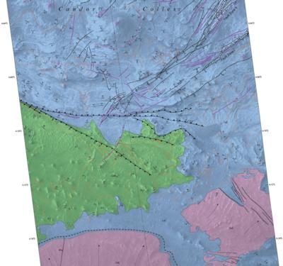
The shaken sediments formed features that now appear as a series of low hills apparent in a geological map based on NASA images. The map was released today by the U.S. Geological Survey (USGS).

This map of the western Candor Chasma canyon within Mars' Valles Marineris is the highest-resolution Martian geological map ever relased by USGS. It is derived from images taken by the High Resolution Imaging Science Experiment (HiRISE) camera on NASA's Mars Reconnaissance Orbiter, which reveal details smaller than a desk.

"This new map shows that at the time these sediments were deposited, a part of west Candor Chasma, specifically Condor Colles, contained numerous shallow, spring-fed lakes," said map author Chris Okubo of the USGS Astrogeology Science Center, Flagstaff, Arizona. "These lakes helped to trap wind-blown sand and dust, which accumulated over time and formed the extensive sedimentary deposits we see today."

The wet sediments experienced seismic shaking in "marsquakes" related to movement along several large geological faults in the area. A series of low hills resulted.

Valles Marineris is more than 2,500 miles (4,000 kilometers) long. The conditions under which sedimentary deposits in it formed have been an open issue for decades. Possibilities proposed have included accumulation in lakebeds, volcanic eruptions under glaciers within the canyons, and accumulation of wind-blown sand and dust.

HiRISE is operated by the University of Arizona, Tucson. The instrument was built by Ball Aerospace & Technologies Corp. of Boulder, Colorado. The Mars Reconnaissance Orbiter Project is managed for NASA's Science Mission Directorate in Washington, by NASA's Jet Propulsion Laboratory, Pasadena, California, a division of the California Institute of Technology, also in Pasadena.

(Image provided by USGS)

FMI: Download MapUSGS Blog

Advertisement

More News

ANN's Daily Aero-Term (04.25.24): Airport Rotating Beacon

Airport Rotating Beacon A visual NAVAID operated at many airports. At civil airports, alternating white and green flashes indicate the location of the airport. At military airports>[...]

ANN's Daily Aero-Linx (04.25.24)

Aero Linx: Fly for the Culture Fly For the Culture, Inc. is a 501(c)(3) non-profit organization that serves young people interested in pursuing professions in the aviation industry>[...]

Klyde Morris (04.22.24)

Klyde Is Having Some Issues Comprehending The Fed's Priorities FMI: www.klydemorris.com>[...]

Airborne 04.24.24: INTEGRAL E, Elixir USA, M700 RVSM

Also: Viasat-uAvionix, UL94 Fuel Investigation, AF Materiel Command, NTSB Safety Alert Norges Luftsportforbund chose Aura Aero's little 2-seater in electric trim for their next gli>[...]

Airborne 04.22.24: Rotor X Worsens, Airport Fees 4 FNB?, USMC Drone Pilot

Also: EP Systems' Battery, Boeing SAF, Repeat TBM 960 Order, Japan Coast Guard H225 Buy Despite nearly 100 complaints totaling millions of dollars of potential fraud, combined with>[...]

blog comments powered by Disqus


Advertisement

Advertisement

Podcasts

Advertisement

© 2007 - 2024 Web Development & Design by Pauli Systems, LC