Wed, Apr 26, 2017
Only Park With Its Own Fleet Of UAVs For SAR Operations
An effort to locate two hikers who went missing in the Grand Canyon on April 15 involved the extensive use of drones owned by the National Park Service. But the aircraft were unable to locate the pair after several days of searching.
The hikers were identified in a NPS news release as Lou Ann Merrell, 62, and Jackson Standefer, 14.
On Saturday evening, April 15 the NPS received an alert from a personal locating beacon in a backcountry area of Grand Canyon National Park near the confluence of Tapeats Creek and Thunder River. An Arizona Department of Public Safety helicopter flew to the location where a hiking party reported two members of their party missing.
The party reported that Merrell and Standefer were last seen crossing Tapeats Creek below the confluence with Thunder River when they lost footing and were swept down Tapeats Creek.
Beginning the morning of Sunday, April 16 and lasting through the end of the day Wednesday, April 19, the NPS searched extensively in both the Tapeats Creek area and the area of the Colorado River below the confluence with Tapeats Creek (approximately Colorado River Mile 134). Three teams (approximately 20 people total) searched ground areas along Tapeats Creek and the Colorado River each day staying in the field overnight. In order to cover areas that were inaccessible to the ground searchers, each day the NPS also utilized a helicopter and crew, an unmanned aerial system (UAS) and operator, and an inflatable motor raft and associated search team.

Arizona Department of Public Safety and Uintah County Search and Rescue (Uintah County Sheriff’s Department) assisted in the search.
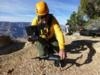
The Associated Press reports that the Grand Canyon is the only national park that has a fleet of drones dedicated to SAR operations. There are five aircraft, and four certified operators are employed by the Park Service.
"Our historic model was to take the helicopter to look and see," said Grand Canyon chief ranger Matt Vandzura. Using a drone offers the ability to get "that same close look but without putting any people at risk. It has dramatically increased our ability to keep our people safe," he said.
In an incident last November, a drone was used to scout a landing area for a helicopter assisting the the recovery of the body of a man who drove off a cliff in the canyon and died. The helicopter was used to lift the car out of the canyon. Last December, the aircraft were used to locate the body of a woman who had jumped to her death in the canyon.
(NPS images)
More News
The Industry Continues to be Rocked By Some Questionable Operations Recent investigations and a great deal of data has resulted in ANN’s SportPlane Resource Guide’s rep>[...]
Make Sure You NEVER Miss A New Story From Aero-News Network Do you ever feel like you never see posts from a certain person or page on Facebook or Instagram? Here’s how you c>[...]
Visual Approach Slope Indicator (VASI) An airport lighting facility providing vertical visual approach slope guidance to aircraft during approach to landing by radiating a directio>[...]
Airport Marking Aids Markings used on runway and taxiway surfaces to identify a specific runway, a runway threshold, a centerline, a hold line, etc. A runway should be marked in ac>[...]
Aero Linx: The Skyhawk Association The Skyhawk Association is a non-profit organization founded by former Skyhawk Pilots which is open to anyone with an affinity for the A-4 Skyhaw>[...]
 Unfortunate... ANN/SportPlane Resource Guide Adds To Cautionary Advisories

