Aero-TV: WSI’s Pilotbrief – Staying Ahead of the Weather | Aero-News Network
Aero-News Network
RSS icon RSS feed
podcast icon MP3 podcast
Subscribe Aero-News e-mail Newsletter Subscribe

Airborne Unlimited -- Most Recent Daily Episodes

Episode Date

Airborne-Monday

Airborne-Tuesday

Airborne-Wednesday Airborne-Thursday

Airborne-Friday

Airborne On YouTube

Airborne-Unlimited-04.22.24

Airborne-Unlimited-04.16.24

Airborne-FlightTraining-04.17.24 Airborne-AffordableFlyers-04.18.24

Airborne-Unlimited-04.19.24

Join Us At 0900ET, Friday, 4/10, for the LIVE Morning Brief.
Watch It LIVE at
www.airborne-live.net

Tue, Nov 24, 2009

Aero-TV: WSI’s Pilotbrief – Staying Ahead of the Weather

WSI Illustrates One Of The Ultimate Services for Enhanced Weather Data

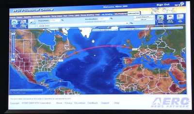
WSI Pilotbrief Online takes the award-winning WSI Pilotbrief weather service suite and provides pilots immediate access to up-to-date enhanced weather updates anywhere, anytime from any Internet-enabled web browser.  One of the few online weather services with FAA Qualified Internet Communications Provider (QICP) certification, Pilotbrief Online allows clients to file flight plans directly to the FAA, as well as view their preferred routes and briefing preferences at any of the numerous WSI Pilotbrief kiosks located in FBO’s throughout the country. 

Through Pilotbrief Online’s secure connection, pilots have direct access to all of WSI’s aviation data including WSI NOWrad radar imagery, IR and Visible Satellite imagery, graphical METARs, TFRs, AIRMETS and SIGMETS.  Radar summary charts indicate potential weather hazards, such as tornadic vortex signatures and mesocyclones, within a planned route for a proactive approach to changing operational conditions.  In addition, the en-route SIGMETS and Flight Plan Guidance provide forecasts for turbulence, convection, and icing, as well as up-to-the-minute Auto Plotted SIGMET and AIRMET charts showing boundaries of in-flight advisories.

With WSI’s Interactive Map, pilots can quickly and easily view global flight data, including route-centric visualization, on a single, easy-to-use interactive workspace. The enhanced map is able to display pole-to-pole, high-resolution digital elevation models with 16 individual weather, hazard, and route overlays.  Such layers include boxes showing areas of turbulence, icing conditions, and even a lightning layer that uses the Global Lightning Network to display real-time lightning detection data for locations throughout the world. 

Pilots can graphically combine various aviation weather and airspace notification layers with just a few mouse clicks.  Developed to be highly extensible, the state-of-the-art interactive map technology allows any future upgrades to be easily added for enhanced options.

FMI: www.wsi.com, www.wsi.com/solutions/aviation/pilotbrief, www.aero-tv.net, www.youtube.com/aerotvnetwork, http://twitter.com/AeroNews

Advertisement

More News

ANN's Daily Aero-Term (04.26.24): DETRESFA (Distress Phrase)

DETRESFA (Distress Phrase) The code word used to designate an emergency phase wherein there is reasonable certainty that an aircraft and its occupants are threatened by grave and i>[...]

ANN's Daily Aero-Linx (04.26.24)

Aero Linx: The International Association of Missionary Aviation (IAMA) The International Association of Missionary Aviation (IAMA) is comprised of Mission organizations, flight sch>[...]

Airborne 04.22.24: Rotor X Worsens, Airport Fees 4 FNB?, USMC Drone Pilot

Also: EP Systems' Battery, Boeing SAF, Repeat TBM 960 Order, Japan Coast Guard H225 Buy Despite nearly 100 complaints totaling millions of dollars of potential fraud, combined with>[...]

Airborne 04.24.24: INTEGRAL E, Elixir USA, M700 RVSM

Also: Viasat-uAvionix, UL94 Fuel Investigation, AF Materiel Command, NTSB Safety Alert Norges Luftsportforbund chose Aura Aero's little 2-seater in electric trim for their next gli>[...]

Airborne-NextGen 04.23.24: UAVOS UVH 170, magni650 Engine, World eVTOL Directory

Also: Moya Delivery Drone, USMC Drone Pilot, Inversion RAY Reentry Vehicle, RapidFlight UAVOS has recently achieved a significant milestone in public safety and emergency services >[...]

blog comments powered by Disqus


Advertisement

Advertisement

Podcasts

Advertisement

© 2007 - 2024 Web Development & Design by Pauli Systems, LC