Wed, Mar 31, 2010
At the 2010 Heli-Expo, the Avidyne Corporation announced all-new
helicopter-specific interfaces for their EX600 Multi-Function
Display (MFD). For helicopter owners and operators, the EX600
MFD will be available as a display replacement for the CRT-based
RDR-1400 radar systems found on most helicopters; more
specifically, the EX600 is approved as a display replacement for
the Telephonics’ RDR-1400-Series Color Weather and Search
& Rescue Radar System.
In addition, Avidyne has added significant new MFD functionality
including the Honeywell MK XXI and MK XXII Helicopter Terrain
Awareness and Warning System (HTAWS). The EX600 has also
achieved the DO-160E vibration qualification requirement necessary
for helicopter operations.
The all-new EX600 Multi-Function Display (MFD), Avidyne’s
next stage in the radar-replacement MFD market for general aviation
aircraft and helicopters, was first announced AOPA’s 2009
Summit. After launching the first stand-alone Flight
Situation Display in 1996, Avidyne continued to push innovation and
product improvement with the FlightMax and EX500 series MFDs; as
stated by Patrick Herguth, Avidyne’s Chief Operating Officer,
“the EX600 raises the bar again with its larger display, and
with the addition of Map Panning, a highly-requested feature that
makes it the most user-friendly MFD available.”

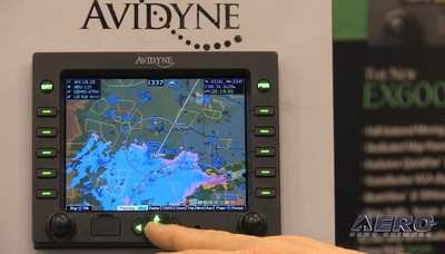
A follow-up to the EX500, the EX600 MFD offers an upgraded
5.8inch diagonal (an increase from the EX500’s 5.5inch
diagonal) and 640x480 pixel display (an increase from the
EX500’s 616x350 pixel display). In addition, the EX600
includes an all-new Map Panning feature that allows pilots to
easily pan and zoom to any location on the moving map. The EX600
also incorporates an exclusive QuickPan™ feature, allowing
pilots to quickly toggle between their present position and a
panned-to position with a single button push. Avidyne hopes that
the two features will dramatically improve a pilots ability to
access and display critical flight data. All EX600s will come with
CMax approach charts, worldwide airport diagrams, and European VFR
chart support.
More News
From 2023 (YouTube Version): Legacy of a Titan Robert (Bob) Anderson Hoover was a fighter pilot, test pilot, flight instructor, and air show superstar. More so, Bob Hoover was an i>[...]
Get The Latest in Aviation News NOW on Instagram Are you on Instagram yet? It's been around for a few years, quietly picking up traction mostly thanks to everybody's new obsession >[...]
Aero Linx: B-52H Stratofortress The B-52H Stratofortress is a long-range, heavy bomber that can perform a variety of missions. The bomber is capable of flying at high subsonic spee>[...]
Altimeter Setting The barometric pressure reading used to adjust a pressure altimeter for variations in existing atmospheric pressure or to the standard altimeter setting (29.92).>[...]
"Knowing that we play an active part in bettering people's lives is extremely rewarding. My team and I are very thankful for the opportunity to be here and to help in any way we ca>[...]
 Classic Aero-TV: Remembering Bob Hoover

