Memorial To UTA Flight 772 Visible On Google Earth | Aero-News Network
Aero-News Network
RSS icon RSS feed
podcast icon MP3 podcast
Subscribe Aero-News e-mail Newsletter Subscribe

Airborne Unlimited -- Most Recent Daily Episodes

Episode Date

Airborne-Monday

Airborne-Tuesday

Airborne-Wednesday Airborne-Thursday

Airborne-Friday

Airborne On YouTube

Airborne-Unlimited-04.29.24

Airborne-Unlimited-04.23.24

Airborne-Unlimited-04.24.24 Airborne-FltTraining-04.25.24

Airborne-Unlimited-04.26.24

Wed, Nov 06, 2013

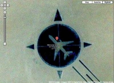
Memorial To UTA Flight 772 Visible On Google Earth

Plane Downed By Libyan Terrorists With A Bomb In The Sahara Desert

On September 19, 1989, Libyan Terrorists planted a briefcase bomb aboard UTA Flight 772 traveling from Brazzavile in the Republic of Congo to Chad and then on to Paris. The bomb detonated over the Sahara Desert, destroying the DC-10 and killing all 170 people on board.

A memorial to those lost on the flight was created in 2007, but given it's desolate location, let's just say it's not a major tourist attraction.

But that doesn't mean you can’t see the memorial, thanks to the magic that is the Internet and Google Earth or Google Maps. A story appearing on The Blaze reports that by typing in 16°51'53"N, 11°57'13"E and zooming down to near ground level, an image of the outline of a DC10 in a compass rose indicating the airplane's route of flight appears.

The memorial is composed mostly of black rocks carefully arranged in the shape of the compass rose, with the desert sand showing through in the outline of the airplane.

Six Libyans were eventually convicted of planting the bomb that brought down the airplane.

(Image from Google Maps)

FMI: http://www.viralnova.com/i-noticed-this-tiny-thing-on-google-maps-and-when-i-zoomed-in-well-nothing-could-prepare-me/

Advertisement

More News

Unfortunate... ANN/SportPlane Resource Guide Adds To Cautionary Advisories

The Industry Continues to be Rocked By Some Questionable Operations Recent investigations and a great deal of data has resulted in ANN’s SportPlane Resource Guide’s rep>[...]

ANN FAQ: Turn On Post Notifications

Make Sure You NEVER Miss A New Story From Aero-News Network Do you ever feel like you never see posts from a certain person or page on Facebook or Instagram? Here’s how you c>[...]

ANN's Daily Aero-Term (04.29.24): Visual Approach Slope Indicator (VASI)

Visual Approach Slope Indicator (VASI) An airport lighting facility providing vertical visual approach slope guidance to aircraft during approach to landing by radiating a directio>[...]

ANN's Daily Aero-Term (04.28.24): Airport Marking Aids

Airport Marking Aids Markings used on runway and taxiway surfaces to identify a specific runway, a runway threshold, a centerline, a hold line, etc. A runway should be marked in ac>[...]

ANN's Daily Aero-Linx (04.28.24)

Aero Linx: The Skyhawk Association The Skyhawk Association is a non-profit organization founded by former Skyhawk Pilots which is open to anyone with an affinity for the A-4 Skyhaw>[...]

blog comments powered by Disqus


Advertisement

Advertisement

Podcasts

Advertisement

© 2007 - 2024 Web Development & Design by Pauli Systems, LC