Taranis Unveils Enhanced Platform For Aerial Imagery Insights Into Farming | Aero-News Network
Aero-News Network
RSS icon RSS feed
podcast icon MP3 podcast
Subscribe Aero-News e-mail Newsletter Subscribe

Airborne Unlimited -- Most Recent Daily Episodes

Episode Date

Airborne-Monday

Airborne-Tuesday

Airborne-Wednesday Airborne-Thursday

Airborne-Friday

Airborne On YouTube

Airborne-Unlimited-04.29.24

Airborne-Unlimited-04.23.24

Airborne-Unlimited-04.24.24 Airborne-FltTraining-04.25.24

Airborne-Unlimited-04.26.24

Thu, Mar 14, 2019

Taranis Unveils Enhanced Platform For Aerial Imagery Insights Into Farming

Debuts Holistic And Centralized Platform, Providing Advanced Actionable Insights For Clients

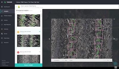
Precision agriculture solution provider Taranis has announced the launch of its updated, insights-centered platform. The company has also expanded its fleet to over one hundred manned aircrafts and autonomous drones increasing reach for customers worldwide.

By 2050, food production will have to grow by 70% to feed a growing population, and farmers and agriculture retailers are demanding tools that can help them glean insights into how to improve their yields. Taranis has developed the leading platform for aerial imagery insights for agriculture, utilizing deep-learning technology combined with high-speed UAVs and manned aircrafts to enable farmers to predict and prevent threats to over 20 million acres of crops on a granular level, such as identifying an actual type of insect on a singular leaf. These unprecedented insights help farmers to better manage crops around seed emergence, weeds, insect damage, nutrition deficiency, fertilizer top and side dressing, yield estimation, harvest priority and automated scouting.

The solution merges the benefits from its existing platform with the capabilities of Mavryx's aerial imagery platform-- a company acquired by Taranis in 2018. This includes insights from Taranis' AI2 (sub millimeter imagery samples) and UHR (high resolution full field imagery to recognize problematic zones), combined with other industry-standard technologies like satellite images and weather forecasts. Taranis' updated platform presents farmers with clear, summarized insights in real-time, enabling them to make quick decisions, rather than necessitating them to dig through layers of extraneous information.

"There is an enormous demand among farmers, and even leading agriculture retailers, for new technologies that can help streamline and improve the food production process," says Ofir Schlam, CEO of Taranis. "But those technologies can be complex to understand, and even harder to use. We hope that by bringing all of Taranis' easy-to-use products and offerings under one roof, we can provide farmers with a better way to monitor their fields, allowing them to make informed decisions and act on them quickly."

The company's enhanced platform is streamlined for the hierarchy and work flow of the farming retail chain and will seamlessly integrate with Taranis' partner companies, such as John Deere and Veris. Since the company's inception, Taranis has made huge advancements in precision agriculture technology, striving to provide farmers with the best solutions, solving issues from the first step of farming – emergence – all the way to personalized prescriptions for crop threats.

(Image provided with Taranis news release)

FMI: www.taranis.ag

Advertisement

More News

Unfortunate... ANN/SportPlane Resource Guide Adds To Cautionary Advisories

The Industry Continues to be Rocked By Some Questionable Operations Recent investigations and a great deal of data has resulted in ANN’s SportPlane Resource Guide’s rep>[...]

ANN FAQ: Turn On Post Notifications

Make Sure You NEVER Miss A New Story From Aero-News Network Do you ever feel like you never see posts from a certain person or page on Facebook or Instagram? Here’s how you c>[...]

ANN's Daily Aero-Term (04.29.24): Visual Approach Slope Indicator (VASI)

Visual Approach Slope Indicator (VASI) An airport lighting facility providing vertical visual approach slope guidance to aircraft during approach to landing by radiating a directio>[...]

ANN's Daily Aero-Term (04.28.24): Airport Marking Aids

Airport Marking Aids Markings used on runway and taxiway surfaces to identify a specific runway, a runway threshold, a centerline, a hold line, etc. A runway should be marked in ac>[...]

ANN's Daily Aero-Linx (04.28.24)

Aero Linx: The Skyhawk Association The Skyhawk Association is a non-profit organization founded by former Skyhawk Pilots which is open to anyone with an affinity for the A-4 Skyhaw>[...]

blog comments powered by Disqus


Advertisement

Advertisement

Podcasts

Advertisement

© 2007 - 2024 Web Development & Design by Pauli Systems, LC